Payl:Map Gulf of Finland-en.svg

Size of this PNG preview of this SVG file: 800 x 457 ka mga piksel. Uban pang mga resoluyon: 320 x 183 ka mga piksel | 640 x 366 ka mga piksel | 1,024 x 585 ka mga piksel | 1,280 x 731 ka mga piksel | 2,560 x 1,463 ka mga piksel | 1,400 x 800 ka mga piksel.
Tibuok resolusyon (SVG nga payl, nominally 1,400 × 800 pixels, size sa payl: 373 KB)
Mubong sugid:
| Deskripsyon |
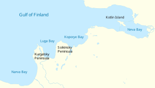
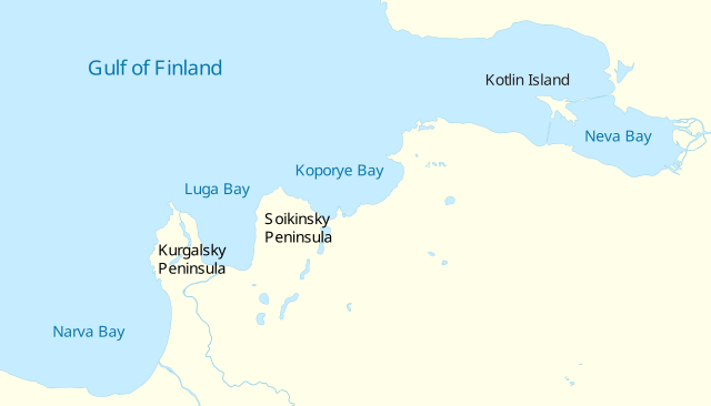
English: Gulf of Finland. Vector map
Русский: Финский залив. Векторная карта
Suomi: Suomenlahti.
Eesti: Soome laht.
Svenska: Finska viken.
Deutsch: Finnische Meerbusen. |
| Petsa | (UTC) |
| Gigikanan | |
| Tagsulat |
|
| Other versions |
[]
|


|
This SVG file contains embedded text that can be translated into your language, using any capable SVG editor, text editor or the SVG Translate tool. For more information see: About translating SVG files. |
| I, the copyright holder of this work, release this work into the public domain. This applies worldwide. In some countries this may not be legally possible; if so: I grant anyone the right to use this work for any purpose, without any conditions, unless such conditions are required by law. |
Kaagi sa payl
I-klik ang petsa/oras aron makit-an ang hulagway sa payl niadtong panahona.
| Petsa/Takna | Thumbnail | Mga dimensyon | Tiggamit | Komento | |
|---|---|---|---|---|---|
| kasamtangan | 16:04, 4 Mayo 2009 | | 1,400 × 800 (373 KB) | Ahnode | {{Information |Description={{en|1=Vector map of the Gulf of Finland, North-Eastern Europe.}} {{ru|1=Векторная карта Финского залива.}} |Source=*Finnish_bay,_NLT_Landsat7.png |Date=2009-05 |
Mga paggamit sa payl
Ang mosunod nga mga panid misumpay niining payl:
Global nga paggamit sa payl
Kining ubang wiki naggamit ning maong payl:
- Paggamit sa ba.wikipedia.org
- Paggamit sa cs.wikipedia.org
- Paggamit sa en.wikipedia.org
- Paggamit sa es.wikipedia.org
- Paggamit sa fi.wikipedia.org
- Paggamit sa fr.wikipedia.org
- Paggamit sa hr.wikipedia.org
- Paggamit sa it.wikipedia.org
- Paggamit sa lt.wikipedia.org
- Paggamit sa nn.wikipedia.org
- Paggamit sa no.wikipedia.org
- Paggamit sa pt.wikipedia.org
- Paggamit sa ru.wikipedia.org
- Paggamit sa sv.wikipedia.org
- Paggamit sa tt.wikipedia.org
- Paggamit sa www.wikidata.org
- Paggamit sa zh.wikipedia.org