Payl:Mesopotamia location map2.svg

Size of this PNG preview of this SVG file: 800 x 507 ka mga piksel. Uban pang mga resoluyon: 320 x 203 ka mga piksel | 640 x 405 ka mga piksel | 1,024 x 648 ka mga piksel | 1,280 x 810 ka mga piksel | 2,560 x 1,621 ka mga piksel | 1,998 x 1,265 ka mga piksel.
Tibuok resolusyon (SVG nga payl, nominally 1,998 × 1,265 pixels, size sa payl: 320 KB)
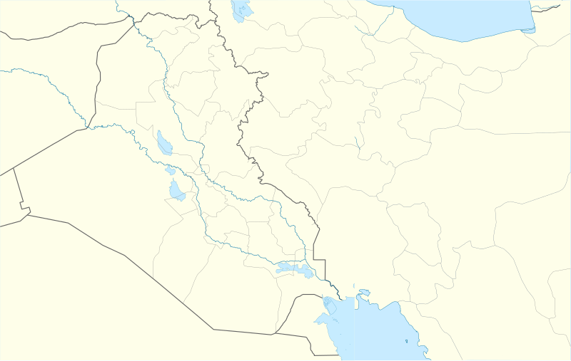
| Deskripsyon | Location map for Mesopotamia (second version) |
| Petsa | (UTC) |
| Gigikanan | |
| Tagsulat |
|
| This is a retouched picture, which means that it has been digitally altered from its original version. The original can be viewed here: Iraq location map.svg:
|
This file is licensed under the Creative Commons Attribution-Share Alike 3.0 Unported license.
- Libre ka:
- sa pagsabwag – sa pagkopya, pag-apod-apod ug pagsabwag sa hinimo
- sa pag-remix – sa pag-adap sa binuhat
- Ubos sa mosunod nga mga kondisyon:
- atribusyon – Kinahanglan nimo nga hatagan ang angay nga kredito, maghatag usa ka link sa lisensya, ug ipakita kung adunay mga pagbag-o. Mahimo nimo kini buhaton sa bisan unsang makatarunganon nga paagi, apan dili sa bisan unsang paagi nga nagsugyot nga gi-endorso ka sa licensor o ang imong paggamit.
- share parehas – Kung imong gi-remix, gibag-o, o gibase sa materyal, kinahanglan nimo nga iapod-apod ang imong mga kontribusyon sa ilawom sa parehas o katugma nga lisensya sama sa orihinal.
Original upload log
This image is a derivative work of the following images:
- File:Iran_location_map.svg licensed with Cc-by-sa-3.0, GFDL
- 2010-07-11T20:08:23Z Uwe Dedering 1200x1071 (655114 Bytes) 31. province Alborz
- 2010-02-18T17:44:29Z Uwe Dedering 1200x1071 (721726 Bytes) Bahrain above water, no disputed countries
- 2010-02-18T13:00:48Z Uwe Dedering 1200x1071 (725716 Bytes) {{Information |Description={{en|1=Location map of Iran. Equirectangular projection. Strechted by 118.0%. Geographic limits of the map: * N: 40.0° N * S: 24.5° N * W: 43.5° E * E: 64.0° E Made with Natural Earth. Fre
- File:Iraq_location_map.svg licensed with Cc-by-sa-3.0, GFDL
- 2008-08-21T20:36:28Z NordNordWest 1241x1264 (323475 Bytes) {{Information |Description= {{de|Positionskarte von [[:de:Irak|Irak]]}} Quadratische Plattkarte, N-S-Streckung 115 %. Geographische Begrenzung der Karte: * N: 37.7° N * S: 28.4° N * W: 38.4° O * O: 48.9° O {{en|Location m
Uploaded with derivativeFX
Kaagi sa payl
I-klik ang petsa/oras aron makit-an ang hulagway sa payl niadtong panahona.
| Petsa/Takna | Thumbnail | Mga dimensyon | Tiggamit | Komento | |
|---|---|---|---|---|---|
| kasamtangan | 12:51, 28 Oktubre 2010 | | 1,998 × 1,265 (320 KB) | 배우는사람 | {{Information |Description=Location map for Mesopotamia (second version) |Source=*File:Iran_location_map.svg *File:Iraq_location_map.svg |Date=2010-10-28 12:50 (UTC) |Author=*File:Iran_location_map.svg: Uwe Dedering |
Mga paggamit sa payl
Ang mosunod nga mga panid misumpay niining payl:
Global nga paggamit sa payl
Kining ubang wiki naggamit ning maong payl:
- Paggamit sa am.wikipedia.org
- Paggamit sa ar.wikipedia.org
- Paggamit sa da.wikipedia.org
- Paggamit sa de.wikipedia.org
- Paggamit sa en.wikipedia.org
- Paggamit sa es.wikipedia.org
- Paggamit sa fa.wikipedia.org
- Paggamit sa fr.wikipedia.org
- Paggamit sa ja.wikipedia.org
- Paggamit sa kn.wikipedia.org
- Paggamit sa ko.wikipedia.org
View more global usage of this file.