Payl:Montanchez.(Cáceres) DSCN0134.JPG

Gidak-on ning maong paunang tan-aw: 800 x 600 ka mga piksel. Uban pang mga resoluyon: 320 x 240 ka mga piksel | 640 x 480 ka mga piksel | 1,024 x 768 ka mga piksel | 1,280 x 960 ka mga piksel | 2,560 x 1,920 ka mga piksel | 3,264 x 2,448 ka mga piksel.
Tibuok resolusyon (3,264 × 2,448 pixels, size sa payl: 3.16 MB, MIME type: image/jpeg)
_DSCN0134.JPG)
Mubong sugid:
| Deskripsyon |
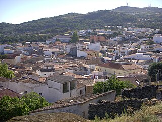
Español: El Castillo está coronado por el Monte Viejo (Montancil o Monte Tances). Sus vinos y jamones ibéricos tienen fama reconocida. Considerables pendientes y frecuentes quiebros de sus calles.
Situación: 39.225658 -6.154807 Rumbo: 214 SO Codigo postal: 10170 Comarca: Comarca de Montánchez. Mancomunidad: Sierra de Montánchez. Pueblos cercanos: Abalá del Caudillo, Torre de Santa María, Zarza de Montánchez, Valdemorales, Almoharín, Arroyomolinos, Alcuescar, Casas de Don Antonio. Alrededores cercanos: El Quemado, Recuera, nacimiento del río Salor, el pocito, prado barbudo, el hornillo. maps.google.es/maps/ms?msa=0&msid=1091110791847002440... |
| Gigikanan | http://farm5.static.flickr.com/4085/5059382096_4401a4c818.jpg |
| Tagsulat | Cotallo-nonocot |
| Camera location | | View this and other nearby images on: OpenStreetMap |
|---|
_DSCN0134.JPG¶ms=039.225658_N_-006.154807_E_globe:Earth_type:camera_alt:734_source:exif_&language=ceb)
Pagtugot
I, the copyright holder of this work, hereby publish it under the following licenses:

|
Gitugot ang pagkopya, pag-apud-apod o/ug pag-usab ning maong dokumento ubos sa mga termino sa GNU Free Documentation License, Version 1.2 o mas bag-ong bersiyon nga gimantala sa Free Software Foundation; nga walay Invariant Sections, walay Front-Cover Texts, ug walay Back-Cover Texts. Ang kopya sa lisensiya gilakip sa bahin nga giulohang GNU Free Documentation License. |
This file is licensed under the Creative Commons Attribution-Share Alike 3.0 Unported license.
- Libre ka:
- sa pagsabwag – sa pagkopya, pag-apod-apod ug pagsabwag sa hinimo
- sa pag-remix – sa pag-adap sa binuhat
- Ubos sa mosunod nga mga kondisyon:
- atribusyon – Kinahanglan nimo nga hatagan ang angay nga kredito, maghatag usa ka link sa lisensya, ug ipakita kung adunay mga pagbag-o. Mahimo nimo kini buhaton sa bisan unsang makatarunganon nga paagi, apan dili sa bisan unsang paagi nga nagsugyot nga gi-endorso ka sa licensor o ang imong paggamit.
- share parehas – Kung imong gi-remix, gibag-o, o gibase sa materyal, kinahanglan nimo nga iapod-apod ang imong mga kontribusyon sa ilawom sa parehas o katugma nga lisensya sama sa orihinal.
You may select the license of your choice.
Kaagi sa payl
I-klik ang petsa/oras aron makit-an ang hulagway sa payl niadtong panahona.
| Petsa/Takna | Thumbnail | Mga dimensyon | Tiggamit | Komento | |
|---|---|---|---|---|---|
| kasamtangan | 08:48, 19 Oktubre 2010 | | 3,264 × 2,448 (3.16 MB) | Cotallo-nonocot | {{Information |Description={{es|1=El Castillo está coronada por el Monte Viejo (Montancil o Monte Tances) . Sus vinos y jamones ibéricos tienen fama reconocida. Considerables pendientes y los frecuentes quiebros de sus calles. Sierra Altitud : 734 m. |
Mga paggamit sa payl
Ang mosunod nga 3 panid misumpay niining payl:
Global nga paggamit sa payl
Kining ubang wiki naggamit ning maong payl:
- Paggamit sa an.wikipedia.org
- Paggamit sa ar.wikipedia.org
- Paggamit sa arz.wikipedia.org
- Paggamit sa br.wikipedia.org
- Paggamit sa ca.wikipedia.org
- Paggamit sa ce.wikipedia.org
- Paggamit sa en.wikipedia.org
- Paggamit sa eo.wikipedia.org
- Paggamit sa es.wikipedia.org
- Paggamit sa eu.wikipedia.org
- Paggamit sa ext.wikipedia.org
- Paggamit sa fr.wikipedia.org
- Paggamit sa hu.wikipedia.org
- Paggamit sa ia.wikipedia.org
- Paggamit sa it.wikipedia.org
- Paggamit sa ka.wikipedia.org
- Paggamit sa lld.wikipedia.org
- Paggamit sa lmo.wikipedia.org
- Paggamit sa mt.wikipedia.org
- Paggamit sa pl.wikipedia.org
- Paggamit sa ro.wikipedia.org
- Paggamit sa ru.wikipedia.org
- Paggamit sa sv.wikipedia.org
- Paggamit sa tt.wikipedia.org
- Paggamit sa uz.wikipedia.org
- Paggamit sa vec.wikipedia.org
- Paggamit sa vi.wikipedia.org
- Paggamit sa www.wikidata.org
- Paggamit sa zh-min-nan.wikipedia.org
- Paggamit sa zh.wikipedia.org
_DSCN0134.JPG)