Payl:Mt. Fuji and Keiyo petrochemical complex.JPG
Gidak-on ning maong paunang tan-aw: 800 x 533 ka mga piksel. Uban pang mga resoluyon: 320 x 213 ka mga piksel | 640 x 427 ka mga piksel | 1,024 x 683 ka mga piksel | 1,280 x 853 ka mga piksel | 2,560 x 1,707 ka mga piksel | 6,000 x 4,000 ka mga piksel.
Tibuok resolusyon (6,000 × 4,000 pixels, size sa payl: 16.19 MB, MIME type: image/jpeg)
Mubong sugid:
| Deskripsyon |
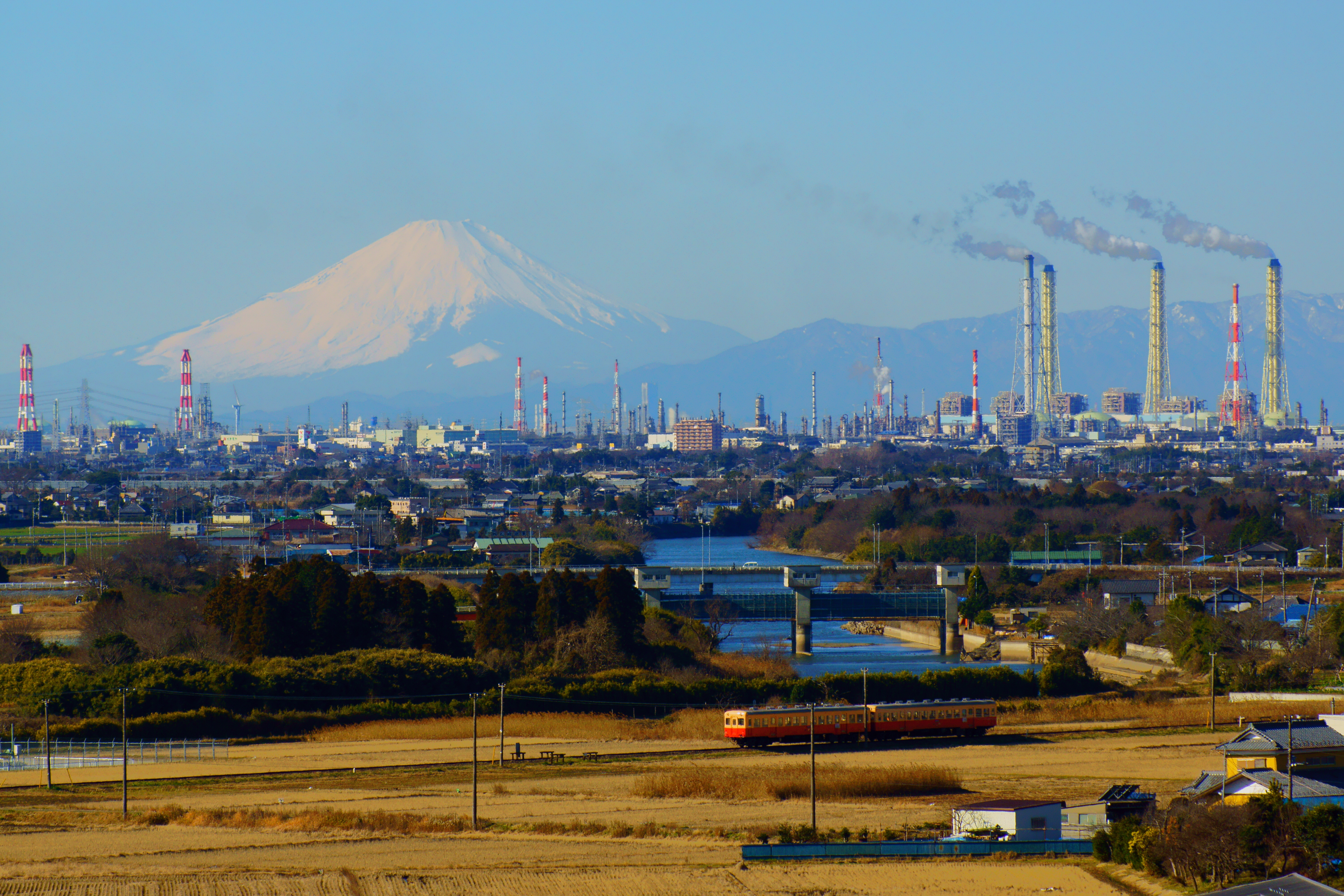
English: This is the distant view of the Keiyo industrial belt where Mt. Fuji was a background. Three chimneys in the right are Anegasaki LNG thermal power plant (3,600,000 kilowatts of output). The Highest chimney in the left of Anegasaki LNG thermal power plant is Idemitsu Chiba oil refinery (220,000 barrels of daily throughput). The chimney applied by red and white in the right is Mitsui Chemicals Chiba factory. Three chimneys in the left are Sumitomo Chemical Chiba factory. 33% of the ethylene consumed in Japan is made at Keiyo industrial belt. |
| Petsa | Taken on 3 Enero 2015 10:39:40 |
| Gigikanan | Kaugalingong trabaho |
| Tagsulat | Nanashinodensyaku |
| Camera location | | View this and other nearby images on: OpenStreetMap |
|---|
Pagtugot
I, the copyright holder of this work, hereby publish it under the following license:
This file is licensed under the Creative Commons Attribution-Share Alike 4.0 International license.
- Libre ka:
- sa pagsabwag – sa pagkopya, pag-apod-apod ug pagsabwag sa hinimo
- sa pag-remix – sa pag-adap sa binuhat
- Ubos sa mosunod nga mga kondisyon:
- atribusyon – Kinahanglan nimo nga hatagan ang angay nga kredito, maghatag usa ka link sa lisensya, ug ipakita kung adunay mga pagbag-o. Mahimo nimo kini buhaton sa bisan unsang makatarunganon nga paagi, apan dili sa bisan unsang paagi nga nagsugyot nga gi-endorso ka sa licensor o ang imong paggamit.
- share parehas – Kung imong gi-remix, gibag-o, o gibase sa materyal, kinahanglan nimo nga iapod-apod ang imong mga kontribusyon sa ilawom sa parehas o katugma nga lisensya sama sa orihinal.
Kaagi sa payl
I-klik ang petsa/oras aron makit-an ang hulagway sa payl niadtong panahona.
| Petsa/Takna | Thumbnail | Mga dimensyon | Tiggamit | Komento | |
|---|---|---|---|---|---|
| kasamtangan | 06:01, 7 Enero 2015 | | 6,000 × 4,000 (16.19 MB) | Nanashinodensyaku | User created page with UploadWizard |
Mga paggamit sa payl
Ang mosunod nga mga panid misumpay niining payl:
Global nga paggamit sa payl
Kining ubang wiki naggamit ning maong payl:
- Paggamit sa ar.wikipedia.org
- Paggamit sa ca.wikipedia.org
- Paggamit sa ce.wikipedia.org
- Paggamit sa cs.wikipedia.org
- Paggamit sa cy.wikipedia.org
- Paggamit sa da.wikipedia.org
- Paggamit sa de.wikipedia.org
- Paggamit sa de.wikivoyage.org
- Paggamit sa en.wikipedia.org
- Paggamit sa eu.wikipedia.org
- Paggamit sa fr.wikivoyage.org
- Paggamit sa ga.wikipedia.org
- Paggamit sa gl.wikipedia.org
- Paggamit sa he.wikipedia.org
- Paggamit sa hy.wikipedia.org
- Paggamit sa ja.wikipedia.org
- Paggamit sa ko.wikipedia.org
- Paggamit sa lt.wikipedia.org
- Paggamit sa mn.wikipedia.org
- Paggamit sa no.wikipedia.org
- Paggamit sa oc.wikipedia.org
- Paggamit sa os.wikipedia.org
- Paggamit sa pl.wikipedia.org
- Paggamit sa pt.wikipedia.org
- Paggamit sa ru.wikinews.org
- Paggamit sa sr.wikipedia.org
- Paggamit sa tg.wikipedia.org
- Paggamit sa tr.wikipedia.org
- Paggamit sa tt.wikipedia.org
- Paggamit sa vi.wikipedia.org
- Paggamit sa www.wikidata.org