Payl:Norfolk Island location map.svg

Size of this PNG preview of this SVG file: 609 x 599 ka mga piksel. Uban pang mga resoluyon: 244 x 240 ka mga piksel | 488 x 480 ka mga piksel | 780 x 768 ka mga piksel | 1,040 x 1,024 ka mga piksel | 2,081 x 2,048 ka mga piksel | 1,201 x 1,182 ka mga piksel.
Tibuok resolusyon (SVG nga payl, nominally 1,201 × 1,182 pixels, size sa payl: 88 KB)
Mubong sugid:
| Deskripsyon |
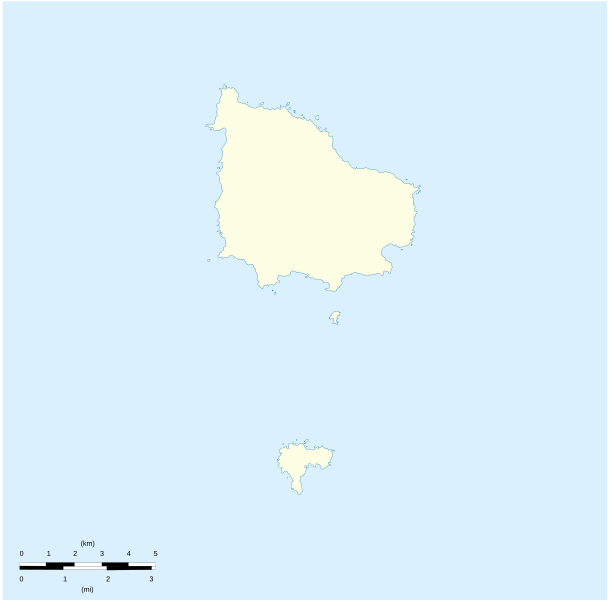
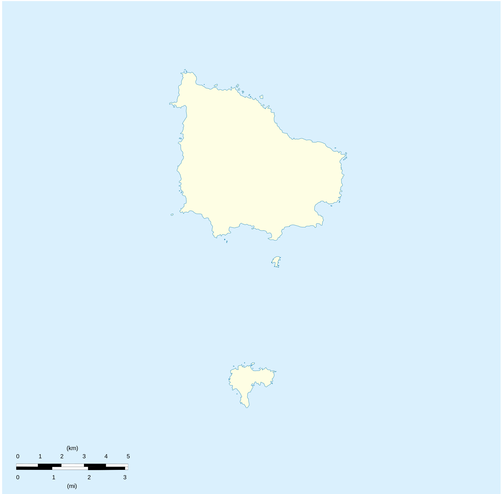
English: Location map of Norfolk_Island
Equirectangular projection. Geographic limits of the map:
Français : Carte de localisation des Île Norfolk
projection equirectangulaire. Les limites géographiques sont
|
| Petsa | |
| Gigikanan |
Kaugalingong trabaho Détail de la carte Norfolk Island [1] Détail de la carte Nepean Island [2] Détail de la carte Philip Island [3] |
| Tagsulat | Xfigpower |
Pagtugot
I, the copyright holder of this work, hereby publish it under the following licenses:

|
Gitugot ang pagkopya, pag-apud-apod o/ug pag-usab ning maong dokumento ubos sa mga termino sa GNU Free Documentation License, Version 1.2 o mas bag-ong bersiyon nga gimantala sa Free Software Foundation; nga walay Invariant Sections, walay Front-Cover Texts, ug walay Back-Cover Texts. Ang kopya sa lisensiya gilakip sa bahin nga giulohang GNU Free Documentation License. |
This file is licensed under the Creative Commons Attribution 3.0 Unported license.
- Libre ka:
- sa pagsabwag – sa pagkopya, pag-apod-apod ug pagsabwag sa hinimo
- sa pag-remix – sa pag-adap sa binuhat
- Ubos sa mosunod nga mga kondisyon:
- atribusyon – Kinahanglan nimo nga hatagan ang angay nga kredito, maghatag usa ka link sa lisensya, ug ipakita kung adunay mga pagbag-o. Mahimo nimo kini buhaton sa bisan unsang makatarunganon nga paagi, apan dili sa bisan unsang paagi nga nagsugyot nga gi-endorso ka sa licensor o ang imong paggamit.
You may select the license of your choice.
Kaagi sa payl
I-klik ang petsa/oras aron makit-an ang hulagway sa payl niadtong panahona.
| Petsa/Takna | Thumbnail | Mga dimensyon | Tiggamit | Komento | |
|---|---|---|---|---|---|
| kasamtangan | 20:41, 10 Agosto 2010 | | 1,201 × 1,182 (88 KB) | Xfigpower | {{Information |Description={{en|1=Location map of Norfolk_Island|}} Equirectangular projection. Geographic limits of the map: * N: 28°58' S * S: 29°10' S * W: 167°52' E * E: 168°02 E}} {{fr|1=Location map of [[:en:Norf |
Mga paggamit sa payl
Ang mosunod nga 64 panid misumpay niining payl:
- Anson Bay
- Anson Bay (luuk sa Norfolk Island)
- Anson Point
- Anson Point (punta)
- Ball Bay
- Ball Bay (luuk sa Norfolk Island)
- Bird Rock
- Bradley Rocks
- Broken Bridge Creek
- Broken Bridge Creek (suba sa Norfolk Island)
- Cascade Bay
- Cascade Bay (luuk sa Norfolk Island)
- Cascade Creek
- Cascade Creek (suba sa Norfolk Island)
- Collins Head
- Collins Head (punta sa Pulo sa Norfolk)
- Cresswell Bay
- Creswell Bay
- Duncombe Bay
- Emily Bay
- Emily Bay (luuk sa Pulo sa Norfolk)
- Flat Rock
- Headstone Point
- Hunter Point
- Jacobs Rock
- Kingston
- Kingston (ulohang dakbayan sa Norfolk Island)
- Mount Bates
- Mount Bates (bukid sa Pulo sa Norfolk)
- Mount Pitt
- Mount Pitt (bukid sa Norfolk Island)
- Nepean Island
- Nepean Island (pulo sa Norfolk Island)
- Norfolk Island
- Norfolk Island (pagklaro)
- Norfolk Island Airport
- Norfolk Island National Park
- Norfolk Ridge
- Philip Island (pulo sa Norfolk Island)
- Point Blackbourne
- Point Howe
- Point Howe (punta)
- Point Hunter
- Point Ross
- Point Vincent
- Point Vincent (punta)
- Puppys Point
- Rocky Point
- Rocky Point (punta sa Pulo sa Norfolk)
- Rocky Point Creek
- Rocky Point Creek (suba sa Norfolk Island)
- Ross Point
- South Rock
- Steels Point
- Stockyard Creek
- Stockyard Creek (suba sa Norfolk Island)
- Sydney Bay
- Sydney Bay (luuk sa Norfolk Island, lat -29,07, long 167,95)
- Town Creek
- Town Creek (suba sa Norfolk Island)
- Watermill Creek
- Watermill Creek (suba sa Norfolk Island)
- White Rock
- Plantilya:Location map Australia Norfolk Island
Global nga paggamit sa payl
Kining ubang wiki naggamit ning maong payl:
- Paggamit sa af.wikipedia.org
- Paggamit sa ar.wikipedia.org
- Paggamit sa ast.wikipedia.org
- Paggamit sa ba.wikipedia.org
- Paggamit sa be-tarask.wikipedia.org
- Paggamit sa be.wikipedia.org
- Paggamit sa bg.wikipedia.org
- Paggamit sa cs.wikipedia.org
- Paggamit sa de.wikipedia.org
- Paggamit sa de.wikivoyage.org
- Paggamit sa el.wikipedia.org
- Paggamit sa en.wikipedia.org
- Burnt Pine
- Kingston, Norfolk Island
- Norfolk Island Airport
- Norfolk Island National Park
- Template:Infobox Australian place/testcases
- User:Michael!/Project:Location map templates/Australia
- Module:Location map/data/Australia Norfolk Island/doc
- St. Philip Howard Church, Kingston
- Module:Location map/data/Australia Norfolk Island
- Module:Location map/data/Norfolk Island
- COVID-19 pandemic in Norfolk Island
- Module:Location map/data/Norfolk Island/doc
- Norfolk Island rail
- Template:Sandbox/Innesw/Infobox Australian place/testcases
- Paggamit sa eo.wikipedia.org
- Paggamit sa es.wikipedia.org
- Paggamit sa fa.wikipedia.org
- Paggamit sa fr.wikipedia.org
View more global usage of this file.