Payl:North Sea.jpg
Gidak-on ning maong paunang tan-aw: 458 x 599 ka mga piksel. Uban pang mga resoluyon: 183 x 240 ka mga piksel | 367 x 480 ka mga piksel | 587 x 768 ka mga piksel | 783 x 1,024 ka mga piksel | 1,300 x 1,700 ka mga piksel.
Tibuok resolusyon (1,300 × 1,700 pixels, size sa payl: 1.27 MB, MIME type: image/jpeg)
Mubong sugid:
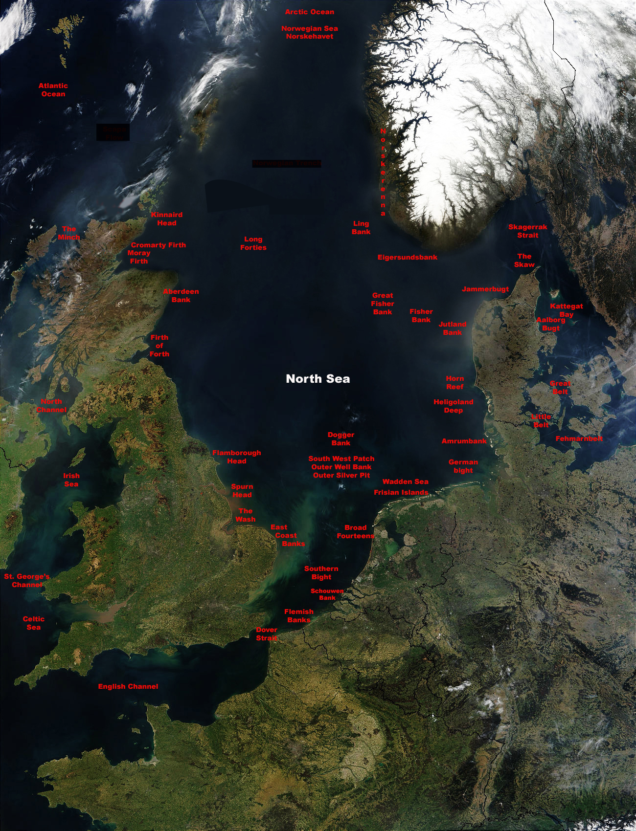
| Deskripsyon | North Sea Map with water systems labelled |
| Gigikanan | Kaugalingong trabaho |
| Tagsulat | SriMesh |
Español: Imagen satélite de la NASA del mar del Norte English: North Sea, Sands of the Sahara over North Sea. Deutsch: Nordsee, NASA-Aufnahme Public Domain. Saharasand über der Nordsee Česky: Družicový snímek – písky ze Sahary nad Severním mořem.
   * Source: http://visibleearth.nasa.gov/view_rec.php?id=5341 archive copy at the Wayback Machine
   * first upload: April 7, 2004 - de:Wikipedia by user:Southpark
   * Date of original NASA source photo - 16 April 2003
Labelling from sources: [1][2][3]
Pagtugot
I, SriMesh, the copyright holder of this work, hereby publishes it under the following licenses:

|
Gitugot ang pagkopya, pag-apud-apod o/ug pag-usab ning maong dokumento ubos sa mga termino sa GNU Free Documentation License, Version 1.2 o mas bag-ong bersiyon nga gimantala sa Free Software Foundation; nga walay Invariant Sections, walay Front-Cover Texts, ug walay Back-Cover Texts. Ang kopya sa lisensiya gilakip sa bahin nga giulohang GNU Free Documentation License. |
| This file is licensed under the Creative Commons Attribution-Share Alike 3.0 Unported license. | ||
| Attribution: I, SriMesh | ||
| ||
| This licensing tag was added to this file as part of the GFDL licensing update. |
This file is licensed under the Creative Commons Attribution-Share Alike 2.5 Generic, 2.0 Generic and 1.0 Generic license.
Attribution: I, SriMesh
- Libre ka:
- sa pagsabwag – sa pagkopya, pag-apod-apod ug pagsabwag sa hinimo
- sa pag-remix – sa pag-adap sa binuhat
- Ubos sa mosunod nga mga kondisyon:
- atribusyon – Kinahanglan nimo nga hatagan ang angay nga kredito, maghatag usa ka link sa lisensya, ug ipakita kung adunay mga pagbag-o. Mahimo nimo kini buhaton sa bisan unsang makatarunganon nga paagi, apan dili sa bisan unsang paagi nga nagsugyot nga gi-endorso ka sa licensor o ang imong paggamit.
- share parehas – Kung imong gi-remix, gibag-o, o gibase sa materyal, kinahanglan nimo nga iapod-apod ang imong mga kontribusyon sa ilawom sa parehas o katugma nga lisensya sama sa orihinal.
You may select the license of your choice.
- ↑ Dirk J.Beets & Adam J.F.van der Spek ((Please provide a date)) The Holocene evolution of the barrier and the back-barrier basins of Belgium and the Netherlands as a function of late Weichselian morphology,relative sea-level rise and sediment supply
- ↑ Do tagging experiments tell the truth? Using electronic tags to[1], (Please provide a date or year)
- ↑ Maptech : Topo Maps Charts Navigation Software GPS and Online MapServer[2], (Please provide a date or year)
Kaagi sa payl
I-klik ang petsa/oras aron makit-an ang hulagway sa payl niadtong panahona.
| Petsa/Takna | Thumbnail | Mga dimensyon | Tiggamit | Komento | |
|---|---|---|---|---|---|
| kasamtangan | 22:54, 22 Disyembre 2007 | | 1,300 × 1,700 (1.27 MB) | SriMesh | {{Information |Description= |Source=self-made |Date= |Author= SriMesh |Permission= |other_versions= }} |
| 23:46, 29 Hulyo 2007 |  | 1,300 × 1,700 (1.26 MB) | SriMesh | {{Information |Description=North Sea Map with water systems labelled |Source=self-made |Date= |Author= SriMesh }} Español: Imagen satélite de la NASA del mar del Norte English: North Sea, Sands of the Sahara over North Sea. Deutsch: No |
Mga paggamit sa payl
Ang mosunod nga mga panid misumpay niining payl:
Global nga paggamit sa payl
Kining ubang wiki naggamit ning maong payl:
- Paggamit sa en.wikipedia.org