Payl:Peace-Athabasca Delta.JPG

Gidak-on ning maong paunang tan-aw: 538 x 600 ka mga piksel. Uban pang mga resoluyon: 215 x 240 ka mga piksel | 430 x 480 ka mga piksel | 825 x 920 ka mga piksel.
Tibuok resolusyon (825 × 920 pixels, size sa payl: 678 KB, MIME type: image/jpeg)
Mubong sugid:
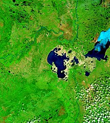
| Deskripsyon | Peace-Athabasca Delta with Lake Claire and mouths of Peace River and Athabasca River. |
| Petsa | Visualization Date: 2002-09-21 |
| Gigikanan | Visible Earth, NASA |
| Tagsulat | Jacques Descloitres, MODIS Land Rapid Response Team, NASA/GSFC |
| Pagtugot (Paggamit pag-usab niini nga file) |
PD |
Cropped from the original 4800 x 3600 JPEG (4.4MB) image.
Pagtugot
| This file is in the public domain in the United States because it was solely created by NASA. NASA copyright policy states that "NASA material is not protected by copyright unless noted". (See Template:PD-USGov, NASA copyright policy page or JPL Image Use Policy.) | ||
 |
Warnings:
|
Kaagi sa payl
I-klik ang petsa/oras aron makit-an ang hulagway sa payl niadtong panahona.
| Petsa/Takna | Thumbnail | Mga dimensyon | Tiggamit | Komento | |
|---|---|---|---|---|---|
| kasamtangan | 14:28, 21 Septiyembre 2006 | | 825 × 920 (678 KB) | Qyd | {{Information |Description= Peace-Athabasca Delta with Lake Claire and mouths of Pecae River and Athabasca River. |Source= [http://visibleearth.nasa.gov/view_rec.php?id=6233 Visible Earth, NASA] |Date= Visualization Date: 2002-09-21 |Author= Jacques Des |
Mga paggamit sa payl
Ang mosunod nga mga panid misumpay niining payl:
Global nga paggamit sa payl
Kining ubang wiki naggamit ning maong payl:
- Paggamit sa bg.wikipedia.org
- Paggamit sa ca.wikipedia.org
- Paggamit sa cv.wikipedia.org
- Paggamit sa de.wikipedia.org
- Paggamit sa en.wikipedia.org
- Paggamit sa es.wikipedia.org
- Paggamit sa fr.wikipedia.org
- Paggamit sa hr.wikipedia.org
- Paggamit sa it.wikipedia.org
- Paggamit sa ja.wikipedia.org
- Paggamit sa lv.wikipedia.org
- Paggamit sa nl.wikipedia.org
- Paggamit sa pl.wikipedia.org
- Paggamit sa pt.wikipedia.org
- Paggamit sa ru.wikipedia.org
- Paggamit sa sr.wikipedia.org
- Paggamit sa sv.wikipedia.org
- Paggamit sa zh.wikipedia.org