Payl:Peta Kota Atambua.png
Gidak-on ning maong paunang tan-aw: 655 x 599 ka mga piksel. Uban pang mga resoluyon: 262 x 240 ka mga piksel | 525 x 480 ka mga piksel | 840 x 768 ka mga piksel | 1,119 x 1,024 ka mga piksel | 1,315 x 1,203 ka mga piksel.
Tibuok resolusyon (1,315 × 1,203 pixels, size sa payl: 300 KB, MIME type: image/png)
Mubong sugid:
| Deskripsyon |
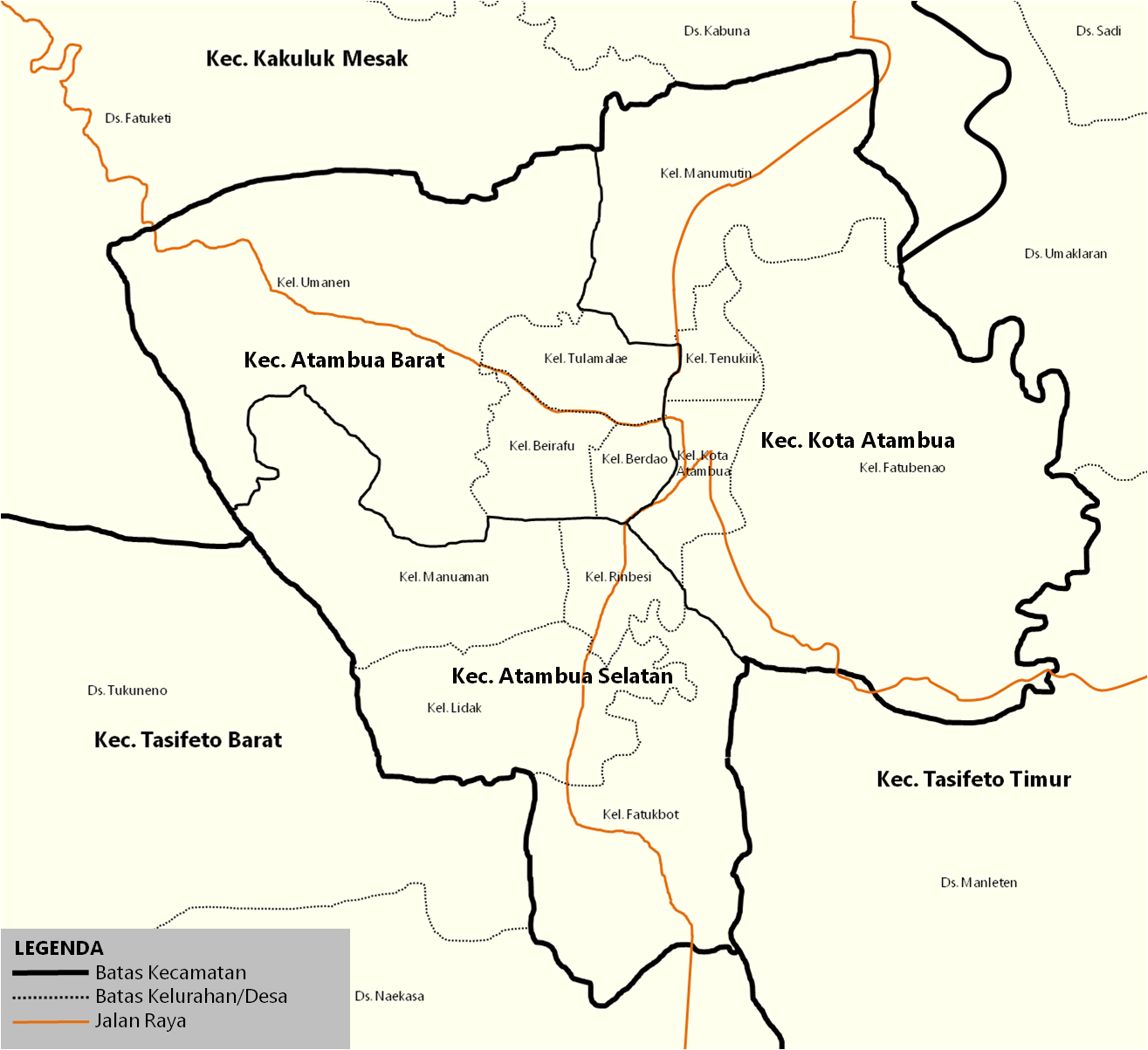
English: Map of the districts inside town of Atambua. Indonesia |
| Gigikanan | id.wikipedia.org |
| Tagsulat | Jolly Frankle |
Pagtugot
| I, the copyright holder of this work, release this work into the public domain. This applies worldwide. In some countries this may not be legally possible; if so: I grant anyone the right to use this work for any purpose, without any conditions, unless such conditions are required by law. |
Original upload log
The original description page was here. All following user names refer to id.wikipedia.
- 2017-07-14 09:37 JollyFrankle 1315×1203× (307479 bytes) Penambahan Legenda
- 2017-07-14 09:31 JollyFrankle 1315×1203× (306739 bytes) Nama Kelurahan, Jalan Raya, Kecamatan Tetangga
- 2017-07-11 03:24 JollyFrankle 1275×1190× (33933 bytes)
Kaagi sa payl
I-klik ang petsa/oras aron makit-an ang hulagway sa payl niadtong panahona.
| Petsa/Takna | Thumbnail | Mga dimensyon | Tiggamit | Komento | |
|---|---|---|---|---|---|
| kasamtangan | 05:20, 20 Disyembre 2018 | | 1,315 × 1,203 (300 KB) | JollyFrankle | {{Information |description ={{en|1=Map of the districts inside town of Atambua. Indonesia}} |date = |source =id.wikipedia.org |author =Jolly Frankle }} == {{Original upload log}} == {{original description page|id.wikipedia|Peta_Kota_Atambua.png}} * 2017-07-14 09:37 JollyFrankle 1315×1203× (307479 bytes) ''<nowiki>Penambahan Legenda</nowiki>'' * 2017-07-14 09:31 JollyFrankle 1315×1203× (306739 bytes) ''<nowiki>Nama K... |
Mga paggamit sa payl
Ang mosunod nga mga panid misumpay niining payl:
Global nga paggamit sa payl
Kining ubang wiki naggamit ning maong payl:
- Paggamit sa ar.wikipedia.org
- Paggamit sa ban.wikipedia.org
- Paggamit sa de.wikipedia.org
- Paggamit sa en.wikivoyage.org
- Paggamit sa id.wikipedia.org
- Kota Atambua, Belu
- Templat:Kota Atambua
- Atambua Selatan, Belu
- Atambua, Atambua, Belu
- Fatubenao, Atambua, Belu
- Manumutin, Atambua, Belu
- Tenukiik, Atambua, Belu
- SMA Negeri 1 Atambua
- Bandar Udara A. A. Bere Tallo
- Atambua
- Transportasi di Kota Atambua
- HUT Kota Atambua
- SMA Katolik Suria Atambua
- Kategori:Kota Atambua
- Sejarah Kota Atambua
- Paggamit sa nl.wikipedia.org
- Paggamit sa pl.wikipedia.org
- Paggamit sa www.wikidata.org