Payl:Political map of Metro Manila.svg

Size of this PNG preview of this SVG file: 333 x 600 ka mga piksel. Uban pang mga resoluyon: 133 x 240 ka mga piksel | 266 x 480 ka mga piksel | 426 x 768 ka mga piksel | 568 x 1,024 ka mga piksel | 1,137 x 2,048 ka mga piksel | 512 x 922 ka mga piksel.
Tibuok resolusyon (SVG nga payl, nominally 512 × 922 pixels, size sa payl: 577 KB)
Mubong sugid:
| Deskripsyon | |
| Petsa | |
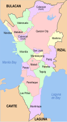
| Gigikanan | Map, colors and stroke widths derived from File:Metro manila map (1).png |
| Tagsulat | Philtro |
.png)
Pagtugot
I, the copyright holder of this work, hereby publish it under the following licenses:
This file is licensed under the Creative Commons Attribution-Share Alike 3.0 Unported license.
- Libre ka:
- sa pagsabwag – sa pagkopya, pag-apod-apod ug pagsabwag sa hinimo
- sa pag-remix – sa pag-adap sa binuhat
- Ubos sa mosunod nga mga kondisyon:
- atribusyon – Kinahanglan nimo nga hatagan ang angay nga kredito, maghatag usa ka link sa lisensya, ug ipakita kung adunay mga pagbag-o. Mahimo nimo kini buhaton sa bisan unsang makatarunganon nga paagi, apan dili sa bisan unsang paagi nga nagsugyot nga gi-endorso ka sa licensor o ang imong paggamit.
- share parehas – Kung imong gi-remix, gibag-o, o gibase sa materyal, kinahanglan nimo nga iapod-apod ang imong mga kontribusyon sa ilawom sa parehas o katugma nga lisensya sama sa orihinal.

|
Gitugot ang pagkopya, pag-apud-apod o/ug pag-usab ning maong dokumento ubos sa mga termino sa GNU Free Documentation License, Version 1.2 o mas bag-ong bersiyon nga gimantala sa Free Software Foundation; nga walay Invariant Sections, walay Front-Cover Texts, ug walay Back-Cover Texts. Ang kopya sa lisensiya gilakip sa bahin nga giulohang GNU Free Documentation License. |
You may select the license of your choice.
Kaagi sa payl
I-klik ang petsa/oras aron makit-an ang hulagway sa payl niadtong panahona.
| Petsa/Takna | Thumbnail | Mga dimensyon | Tiggamit | Komento | |
|---|---|---|---|---|---|
| kasamtangan | 08:14, 11 Nobiyembre 2023 | | 512 × 922 (577 KB) | Hariboneagle927 | update |
| 04:43, 26 Nobiyembre 2021 |  | 512 × 922 (634 KB) | Hariboneagle927 | Reverted to version as of 14:56, 30 September 2021 (UTC) Reverted to version as of 18:14, 25 September 2021 (UTC) Not sure what is the rationale to upload this version. Previous version allowed the viewers to have a context of how big NCR is compared to the surrounding areas. | |
| 03:51, 26 Nobiyembre 2021 |  | 656 × 1,280 (305 KB) | Nissan2020 | Reverted to version as of 12:14, 28 March 2021 (UTC) | |
| 14:56, 30 Septiyembre 2021 |  | 512 × 922 (634 KB) | Hariboneagle927 | fix text | |
| 14:54, 30 Septiyembre 2021 |  | 512 × 922 (467 KB) | Hariboneagle927 | update | |
| 06:12, 4 Hulyo 2021 |  | 700 × 1,260 (517 KB) | Hariboneagle927 | Add Manila South Cemetery exclave | |
| 08:56, 30 Marso 2021 |  | 700 × 1,260 (518 KB) | HueMan1 | Reverted to version as of 15:59, 8 May 2011 (UTC) | |
| 12:14, 28 Marso 2021 |  | 656 × 1,280 (305 KB) | Teamayuiyui | Update Enhanced Version 2021 | |
| 15:59, 8 Mayo 2011 |  | 700 × 1,260 (518 KB) | McVahl | {{Information |Description = Political map of Metro Manila, Philippines |Source = Map, colors and stroke widths derived from File:Metro manila map (1).png |Date = 08 May 2011 |Author = Philtro |Permission = |
.png)
Mga paggamit sa payl
Ang mosunod nga 2 panid misumpay niining payl:
Global nga paggamit sa payl
Kining ubang wiki naggamit ning maong payl:
- Paggamit sa br.wikipedia.org
- Paggamit sa de.wikipedia.org
- Paggamit sa en.wikipedia.org
- Metropolitan Manila Development Authority
- User:BrokenSphere/Userboxes
- User:BrokenSphere/Userboxes/Metro Manila
- Wikipedia talk:WikiProject Userboxes/New Userboxes/Archive 5
- User:Sky Harbor/Userboxes
- User:Matthewprc/Userboxes
- User:NaotoATG
- User:Fythring
- User:Pasawayz
- User:Stacy twain
- User:Alexius08
- User:JParis
- User:DarknovaXIV
- User:KarlcmanRockets
- User:Axxand/about this user!
- User:E Wing
- User:Faizza T
- User:Axxand
- User:Agos at wolf
- User:Pickoneword!
- User:Ryomaandres
- User:Montelaba
- User:Dan-gee-rous
- User:Derrickflores78
- User:Bryan Mayor
- User:Bgh1111
- List of barangays of Metro Manila
- Administrative divisions of Metro Manila
- Index of Metro Manila–related articles
- User:Democratics
- User:Democratics/userboxes
- User:Carlo71201
- User:SilentGanda
- User:Mlgc1998
- User:ThePasayeño
- User:Mx mirav
- Paggamit sa eo.wikipedia.org
- Paggamit sa fi.wikipedia.org
- Paggamit sa fr.wikipedia.org
- Paggamit sa hi.wikipedia.org
- Paggamit sa ia.wikipedia.org
- Paggamit sa it.wikipedia.org
- Paggamit sa ja.wikipedia.org
- Paggamit sa ms.wikipedia.org
- Paggamit sa my.wikipedia.org
- Paggamit sa no.wikipedia.org
- Paggamit sa pl.wikipedia.org
View more global usage of this file.