Payl:Port-Heiden-Airport-diagram.png
Walay mas taas nga resolusyon.
Port-Heiden-Airport-diagram.png (496 × 570 pixels, size sa payl: 41 KB, MIME type: image/png)
Mubong sugid:
| Deskripsyon |
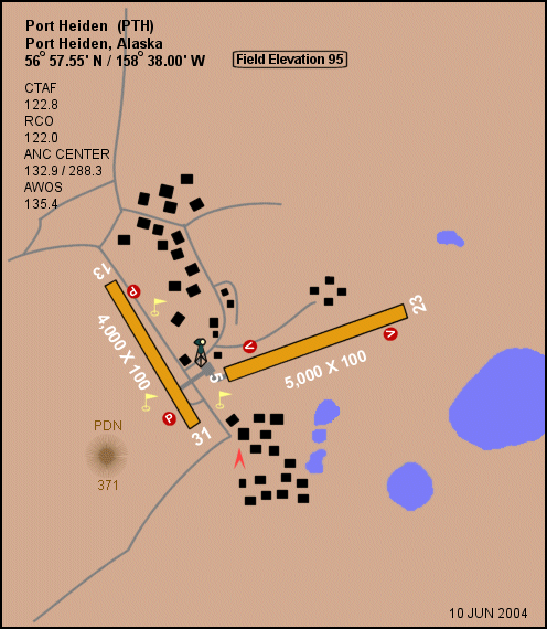
English: Diagram of Port Heiden Airport (FAA: PTH) in Alaska, United States |
| Petsa | |
| Gigikanan |
|
| Tagsulat | Federal Aviation Administration, Alaskan Region |
| Pagtugot (Paggamit pag-usab niini nga file) |
Public domain |
| Object location | | View this and other nearby images on: OpenStreetMap |
|---|
Pagtugot
This image or file is a work of a Federal Aviation Administration employee, taken or made as part of that person's official duties. As a work of the U.S. federal government, the image is in the public domain in the United States.
|
 |
Kaagi sa payl
I-klik ang petsa/oras aron makit-an ang hulagway sa payl niadtong panahona.
| Petsa/Takna | Thumbnail | Mga dimensyon | Tiggamit | Komento | |
|---|---|---|---|---|---|
| kasamtangan | 00:26, 4 Septiyembre 2009 | | 496 × 570 (41 KB) | Zyxw | == {{int:filedesc}} == {{Information | description = {{en|Diagram of {{w|Port Heiden Airport}} (IATA/FAA: PTH) in Alaska, United States}} | date = 2004-06-10 | source = Image: http://www.alaska.faa.gov/fai/images/ARPT_DIAGRAMS/PTH.gif (converted to {{w|.p |
Mga paggamit sa payl
Ang mosunod nga mga panid misumpay niining payl:
Global nga paggamit sa payl
Kining ubang wiki naggamit ning maong payl:
- Paggamit sa arz.wikipedia.org
- Paggamit sa en.wikipedia.org
- Paggamit sa fa.wikipedia.org
- Paggamit sa ro.wikipedia.org
- Paggamit sa ru.wikipedia.org
- Paggamit sa tg.wikipedia.org
- Paggamit sa www.wikidata.org