Payl:Prunella laciniata range map.png
Walay mas taas nga resolusyon.
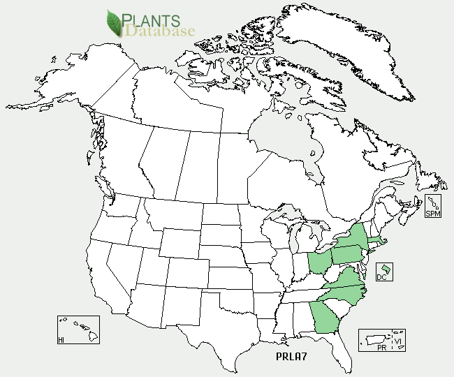
Prunella_laciniata_range_map.png (650 × 540 pixels, size sa payl: 38 KB, MIME type: image/png)
Mubong sugid:
| Deskripsyon |
English: Prunella laciniata range map |
| Gigikanan | http://plants.usda.gov/java/profile?symbol=PRLA7 |
| Tagsulat | USDA |
Pagtugot
| This image is a work of the Natural Resources Conservation Service, part of the United States Department of Agriculture, taken or made as part of an employee's official duties. As a work of the U.S. federal government, the image is in the public domain in the United States. |
Original upload log
Transferred from en.wikipedia to Commons by Quadell using CommonsHelper.
The original description page was here. All following user names refer to en.wikipedia.
- 2009-12-15 19:50 Ecologygirl 650×540× (38519 bytes) {{Information |Description = Prunella laciniata range map |Source = http://plants.usda.gov/java/profile?symbol=PRLA7 |Date = ~~~~~ |Author = [[USDA]] |Permission = |other_versions = }} == Licensing == {{PD-USGov-U
Kaagi sa payl
I-klik ang petsa/oras aron makit-an ang hulagway sa payl niadtong panahona.
| Petsa/Takna | Thumbnail | Mga dimensyon | Tiggamit | Komento | |
|---|---|---|---|---|---|
| kasamtangan | 14:14, 9 Septiyembre 2011 | | 650 × 540 (38 KB) | File Upload Bot (Magnus Manske) | {{BotMoveToCommons|en.wikipedia|year={{subst:CURRENTYEAR}}|month={{subst:CURRENTMONTHNAME}}|day={{subst:CURRENTDAY}}}} {{Information |Description={{en|Prunella laciniata range map}} |Source=Transferred from [http://en.wikipedia.org en.wikipedia]; transfe |
Mga paggamit sa payl
Ang mosunod nga mga panid misumpay niining payl:
Global nga paggamit sa payl
Kining ubang wiki naggamit ning maong payl:
- Paggamit sa cy.wikipedia.org
- Paggamit sa en.wikipedia.org
- Paggamit sa fa.wikipedia.org
- Paggamit sa vi.wikipedia.org