Payl:Punjab district map.png

Gidak-on ning maong paunang tan-aw: 540 x 600 ka mga piksel. Uban pang mga resoluyon: 216 x 240 ka mga piksel | 432 x 480 ka mga piksel | 691 x 768 ka mga piksel | 922 x 1,024 ka mga piksel | 2,467 x 2,741 ka mga piksel.
Tibuok resolusyon (2,467 × 2,741 pixels, size sa payl: 635 KB, MIME type: image/png)

|
This locator map image could be re-created using vector graphics as an SVG file. This has several advantages; see Commons:Media for cleanup for more information. If an SVG form of this image is available, please upload it and afterwards replace this template with
{{vector version available|new image name}}.
It is recommended to name the SVG file “Punjab district map.svg”—then the template Vector version available (or Vva) does not need the new image name parameter. |
Mubong sugid:
| Deskripsyon |
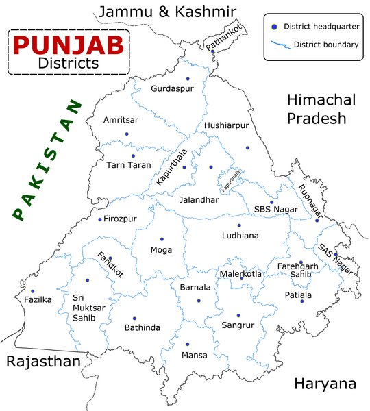
English: State of Punjab (Indian Punjab) with districts marked along with district Headquarters. |
| Petsa | |
| Gigikanan | Self made using Inkscape. Source map referred from Punjab govt. site. |
| Tagsulat | Wikigringo |
Pagtugot
I, the copyright holder of this work, hereby publish it under the following licenses:

|
Gitugot ang pagkopya, pag-apud-apod o/ug pag-usab ning maong dokumento ubos sa mga termino sa GNU Free Documentation License, Version 1.2 o mas bag-ong bersiyon nga gimantala sa Free Software Foundation; nga walay Invariant Sections, walay Front-Cover Texts, ug walay Back-Cover Texts. Ang kopya sa lisensiya gilakip sa bahin nga giulohang GNU Free Documentation License. |
This file is licensed under the Creative Commons Attribution-Share Alike 4.0 International, 3.0 Unported, 2.5 Generic, 2.0 Generic and 1.0 Generic license.
- Libre ka:
- sa pagsabwag – sa pagkopya, pag-apod-apod ug pagsabwag sa hinimo
- sa pag-remix – sa pag-adap sa binuhat
- Ubos sa mosunod nga mga kondisyon:
- atribusyon – Kinahanglan nimo nga hatagan ang angay nga kredito, maghatag usa ka link sa lisensya, ug ipakita kung adunay mga pagbag-o. Mahimo nimo kini buhaton sa bisan unsang makatarunganon nga paagi, apan dili sa bisan unsang paagi nga nagsugyot nga gi-endorso ka sa licensor o ang imong paggamit.
- share parehas – Kung imong gi-remix, gibag-o, o gibase sa materyal, kinahanglan nimo nga iapod-apod ang imong mga kontribusyon sa ilawom sa parehas o katugma nga lisensya sama sa orihinal.
You may select the license of your choice.
Kaagi sa payl
I-klik ang petsa/oras aron makit-an ang hulagway sa payl niadtong panahona.
| Petsa/Takna | Thumbnail | Mga dimensyon | Tiggamit | Komento | |
|---|---|---|---|---|---|
| kasamtangan | 09:25, 10 Enero 2023 | | 2,467 × 2,741 (635 KB) | Saad Ali Khan Pakistan | updated district MalerKotla on map |
| 04:45, 7 Hulyo 2020 |  | 2,467 × 2,741 (867 KB) | Kaushal Bishnoi | New Update version of Punjab District Map with 22 District. | |
| 14:41, 5 Oktubre 2013 |  | 1,094 × 848 (127 KB) | Ras67 | cropped and optimized | |
| 08:40, 28 Abril 2008 |  | 1,211 × 874 (187 KB) | Wikigringo | Uploading a better color version of the file with bigger font size. | |
| 16:01, 26 Abril 2008 |  | 1,269 × 907 (167 KB) | Wikigringo | {{Information |Description=State of Punjab, India with districts marked along with district HQ. |Source=Self made using Inkscape. Source map referred from Punjab govt. site. |Date=04/26/2008 |Author=Wikigringo |Permission= |other_versions= }} |
Mga paggamit sa payl
Ang mosunod nga 3 panid misumpay niining payl:
Global nga paggamit sa payl
Kining ubang wiki naggamit ning maong payl:
- Paggamit sa ar.wikipedia.org
- Paggamit sa azb.wikipedia.org
- Paggamit sa bh.wikipedia.org
- Paggamit sa bn.wikipedia.org
- Paggamit sa ca.wikipedia.org
- Paggamit sa en.wikipedia.org
- Paggamit sa es.wikipedia.org
- Paggamit sa eu.wikipedia.org
- Paggamit sa fa.wikipedia.org
- Paggamit sa fi.wikipedia.org
- Paggamit sa fr.wikipedia.org
- Pendjab (Inde)
- District de Barnala
- District de Faridkot
- District de Fatehgarh Sahib
- District de Fazilka
- District de Firozpur
- District de Gurdaspur
- District de Hoshiarpur
- District de Jalandhar
- District de Kapurthala
- District de Ludhiana
- District de Mansa (Penjab)
- District de Moga
- District de Mohali
- District de Muktsar
- District de Shahid Bhagat Singh Nagar
- District de Pathankot
- District de Patiala
View more global usage of this file.