Payl:Pushkar.jpg

Gidak-on ning maong paunang tan-aw: 800 x 532 ka mga piksel. Uban pang mga resoluyon: 320 x 213 ka mga piksel | 640 x 426 ka mga piksel | 1,024 x 681 ka mga piksel | 1,280 x 851 ka mga piksel | 2,292 x 1,524 ka mga piksel.
Tibuok resolusyon (2,292 × 1,524 pixels, size sa payl: 985 KB, MIME type: image/jpeg)
Mubong sugid:
| Deskripsyon |
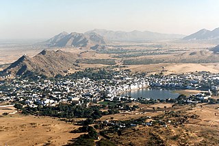
English: Puskhar, Rajasthan, India
Français : Pushkar, Rajasthan, Inde |
| Petsa | |
| Gigikanan | Kaugalingong trabaho |
| Tagsulat | Bernard Gagnon |
| Camera location | | View this and other nearby images on: OpenStreetMap |
|---|
| Object location | | View this and other nearby images on: OpenStreetMap |
|---|
Pagtugot
I, the copyright holder of this work, hereby publish it under the following licenses:

|
Gitugot ang pagkopya, pag-apud-apod o/ug pag-usab ning maong dokumento ubos sa mga termino sa GNU Free Documentation License, Version 1.2 o mas bag-ong bersiyon nga gimantala sa Free Software Foundation; nga walay Invariant Sections, walay Front-Cover Texts, ug walay Back-Cover Texts. Ang kopya sa lisensiya gilakip sa bahin nga giulohang GNU Free Documentation License. |
This file is licensed under the Creative Commons Attribution-Share Alike 3.0 Unported, 2.5 Generic, 2.0 Generic and 1.0 Generic license.
- Libre ka:
- sa pagsabwag – sa pagkopya, pag-apod-apod ug pagsabwag sa hinimo
- sa pag-remix – sa pag-adap sa binuhat
- Ubos sa mosunod nga mga kondisyon:
- atribusyon – Kinahanglan nimo nga hatagan ang angay nga kredito, maghatag usa ka link sa lisensya, ug ipakita kung adunay mga pagbag-o. Mahimo nimo kini buhaton sa bisan unsang makatarunganon nga paagi, apan dili sa bisan unsang paagi nga nagsugyot nga gi-endorso ka sa licensor o ang imong paggamit.
- share parehas – Kung imong gi-remix, gibag-o, o gibase sa materyal, kinahanglan nimo nga iapod-apod ang imong mga kontribusyon sa ilawom sa parehas o katugma nga lisensya sama sa orihinal.
You may select the license of your choice.
| Annotations | This image is annotated: View the annotations at Commons |
Kaagi sa payl
I-klik ang petsa/oras aron makit-an ang hulagway sa payl niadtong panahona.
| Petsa/Takna | Thumbnail | Mga dimensyon | Tiggamit | Komento | |
|---|---|---|---|---|---|
| kasamtangan | 00:09, 10 Hunyo 2011 | | 2,292 × 1,524 (985 KB) | Bgag | better version |
| 18:09, 4 Enero 2009 |  | 2,330 × 1,569 (730 KB) | Bgag | {{Information |Description={{en|1=Puskhar, Rajasthan, India}} {{fr|1=Pushkar, Rajasthan, Inde}} |Source=travail personnel (own work) |Author=Bernard Gagnon |Date=1996-01-26 |Permission= |other_versions= }} {{Location|26|30|0|N|74|33|0|E}} <! |
Mga paggamit sa payl
Ang mosunod nga mga panid misumpay niining payl:
Global nga paggamit sa payl
Kining ubang wiki naggamit ning maong payl:
- Paggamit sa ba.wikipedia.org
- Paggamit sa de.wikipedia.org
- Paggamit sa en.wikipedia.org
- Paggamit sa es.wikipedia.org
- Paggamit sa fi.wikipedia.org
- Paggamit sa fr.wikipedia.org
- Paggamit sa gu.wikipedia.org
- Paggamit sa he.wikipedia.org
- Paggamit sa hi.wikipedia.org
- Paggamit sa hsb.wikipedia.org
- Paggamit sa hu.wikipedia.org
- Paggamit sa incubator.wikimedia.org
- Paggamit sa it.wikivoyage.org
- Paggamit sa ml.wikipedia.org
- Paggamit sa ru.wikipedia.org
- Paggamit sa sv.wikipedia.org
- Paggamit sa ta.wikipedia.org
- Paggamit sa te.wikipedia.org
- Paggamit sa th.wikipedia.org
- Paggamit sa tt.wikipedia.org
- Paggamit sa zh-min-nan.wikipedia.org