Payl:Scotland relief location map.jpg

Gidak-on ning maong paunang tan-aw: 456 x 600 ka mga piksel. Uban pang mga resoluyon: 182 x 240 ka mga piksel | 365 x 480 ka mga piksel | 584 x 768 ka mga piksel | 1,128 x 1,483 ka mga piksel.
Tibuok resolusyon (1,128 × 1,483 pixels, size sa payl: 927 KB, MIME type: image/jpeg)
Mubong sugid:
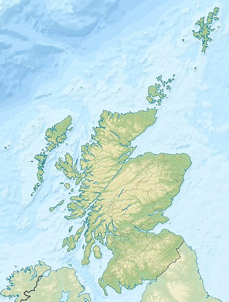
| Deskripsyon | Quadratische Plattkarte, N-S-Streckung 170 %. Geographische Begrenzung der Karte: * N: 61.0° N * S: 54.5° N * W: 8.8° W * O: 0.4° W Equirectangular projection, N/S stretching 170 %. Geographic limits of the map: * N: 61.0° N * S: 54.5° N * W: 8.8° W * E: 0.4° W |
| Petsa | (UTC) |
| Gigikanan | Kaugalingong trabaho |
| Tagsulat |
|
| Other versions |
|

Pagtugot
I, the copyright holder of this work, hereby publish it under the following licenses:
This file is licensed under the Creative Commons Attribution-Share Alike 3.0 Unported license.
Attribution: Eric Gaba, NordNordWest, Uwe Dedering
- Libre ka:
- sa pagsabwag – sa pagkopya, pag-apod-apod ug pagsabwag sa hinimo
- sa pag-remix – sa pag-adap sa binuhat
- Ubos sa mosunod nga mga kondisyon:
- atribusyon – Kinahanglan nimo nga hatagan ang angay nga kredito, maghatag usa ka link sa lisensya, ug ipakita kung adunay mga pagbag-o. Mahimo nimo kini buhaton sa bisan unsang makatarunganon nga paagi, apan dili sa bisan unsang paagi nga nagsugyot nga gi-endorso ka sa licensor o ang imong paggamit.
- share parehas – Kung imong gi-remix, gibag-o, o gibase sa materyal, kinahanglan nimo nga iapod-apod ang imong mga kontribusyon sa ilawom sa parehas o katugma nga lisensya sama sa orihinal.

|
Gitugot ang pagkopya, pag-apud-apod o/ug pag-usab ning maong dokumento ubos sa mga termino sa GNU Free Documentation License, Version 1.2 o mas bag-ong bersiyon nga gimantala sa Free Software Foundation; nga walay Invariant Sections, walay Front-Cover Texts, ug walay Back-Cover Texts. Ang kopya sa lisensiya gilakip sa bahin nga giulohang GNU Free Documentation License. |
You may select the license of your choice.
Original upload log
This image is a derivative work of the following images:
- File:Scotland_location_map.svg licensed with Cc-by-sa-3.0, GFDL
- 2008-10-09T18:27:35Z NordNordWest 1128x1483 (829918 Bytes) {{Information |Description= {{de|Positionskarte von [[:de:Schottland|Schottland]], [[:de:Vereinigtes Königreich|Vereinigtes Königreich]]}} Quadratische Plattkarte, N-S-Streckung 170 %. Geographische Begrenzung der Karte: *
Uploaded with derivativeFX
Kaagi sa payl
I-klik ang petsa/oras aron makit-an ang hulagway sa payl niadtong panahona.
| Petsa/Takna | Thumbnail | Mga dimensyon | Tiggamit | Komento | |
|---|---|---|---|---|---|
| kasamtangan | 23:30, 25 Hunyo 2010 | | 1,128 × 1,483 (927 KB) | Uwe Dedering | {{Information |Description={{de|Positionskarte von Schottland, Vereinigtes Königreich}} Quadratische Plattkarte, N-S-Streckung 170 %. Geographische Begrenzung der Karte: * N: 61.0° N * S: 54.5° N * W: |
Mga paggamit sa payl
Ang mosunod nga 5 panid misumpay niining payl:
Global nga paggamit sa payl
Kining ubang wiki naggamit ning maong payl:
- Paggamit sa ab.wikipedia.org
- Paggamit sa am.wikipedia.org
- Paggamit sa ar.wikipedia.org
- Paggamit sa arz.wikipedia.org
- Paggamit sa ast.wikipedia.org
- Paggamit sa as.wikipedia.org
- Paggamit sa awa.wikipedia.org
- Paggamit sa azb.wikipedia.org
- Paggamit sa az.wikipedia.org
- Paggamit sa ba.wikipedia.org
- Paggamit sa be-tarask.wikipedia.org
- Paggamit sa be.wikipedia.org
View more global usage of this file.