Payl:Shawbury parish church from the village centre.jpg
Walay mas taas nga resolusyon.
Shawbury_parish_church_from_the_village_centre.jpg (640 × 426 pixels, size sa payl: 68 KB, MIME type: image/jpeg)
This is a photo of listed building number 1180331. |
This is a photo of listed building number 1366830. |
Mubong sugid:
| Deskripsyon |
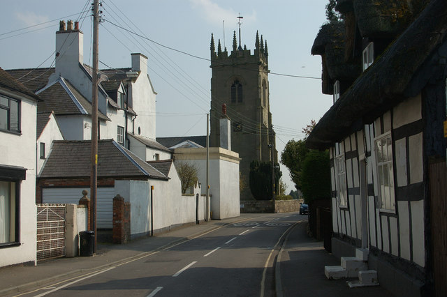
English: View south along Church Street, Shawbury, Shropshire. The timber-framed house on the right is 122 church street, probably 17th-century. The slate-roofed house on the left is the Old Vicarage, which is late 19th-century. The tower belongs to St Mary the Virgin parish church and is probably 15th-century. |
||
| Petsa | |||
| Gigikanan | Geograph.org.uk | ||
| Tagsulat | Row17 | ||
| Pagtugot (Paggamit pag-usab niini nga file) |
This file is licensed under the Creative Commons Attribution-Share Alike 2.0 Generic license. Attribution: Row17
|

| Camera location | | View this and other nearby images on: OpenStreetMap |
|---|
_heading:157.00&language=ceb)
| Object location | | View this and other nearby images on: OpenStreetMap |
|---|
_heading:157.00&language=ceb)
Kaagi sa payl
I-klik ang petsa/oras aron makit-an ang hulagway sa payl niadtong panahona.
| Petsa/Takna | Thumbnail | Mga dimensyon | Tiggamit | Komento | |
|---|---|---|---|---|---|
| kasamtangan | 20:16, 11 Septiyembre 2008 | | 640 × 426 (68 KB) | Stavros1 | {{Information |Description= Shawbury Village and Parish church, Shropshire |Source=http://www.geograph.org.uk/photo/774465 |Date=Tuesday, 22 April, 2008 |Author=Row17 |Permission= {{Geograph|774465|Row17 }} |other_versions= }} [[Category:Churches in Sh |
Mga paggamit sa payl
Ang mosunod nga mga panid misumpay niining payl:
Global nga paggamit sa payl
Kining ubang wiki naggamit ning maong payl:
- Paggamit sa cy.wikipedia.org
- Paggamit sa dag.wikipedia.org
- Paggamit sa en.wikipedia.org
- Paggamit sa es.wikipedia.org
- Paggamit sa fa.wikipedia.org
- Paggamit sa fr.wikipedia.org
- Paggamit sa lld.wikipedia.org
- Paggamit sa pl.wikipedia.org
- Paggamit sa simple.wikipedia.org
- Paggamit sa www.wikidata.org
- Paggamit sa zh-min-nan.wikipedia.org