Payl:Solferino LCD.jpg

Gidak-on ning maong paunang tan-aw: 800 x 450 ka mga piksel. Uban pang mga resoluyon: 320 x 180 ka mga piksel | 640 x 360 ka mga piksel | 1,024 x 576 ka mga piksel | 1,280 x 720 ka mga piksel | 1,920 x 1,080 ka mga piksel.
Tibuok resolusyon (1,920 × 1,080 pixels, size sa payl: 667 KB, MIME type: image/jpeg)
Mubong sugid:
| Deskripsyon |
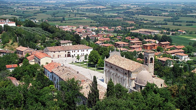
English: View of the town of Solferino and the church of San Pietro in Vincoli, Lombardy, Italy. Solferino was the place of the battle of the same name, which was the trigger for the Swiss Henry Dunant to found what is now known as the Red Cross.
Español: Vista de Solferino y de la iglesia de San Pietro in Vincoli, Lombardia, Italia. Solferino fue el lugar de la batalla del mismo nombre, la cual fue el detonante para que el suizo Henry Dunant fundara lo que hoy se conoce como la Cruz Roja. Français : Vue de la ville de Solférino et de l'église Saint-Pierre-es-Liens, Lombardie, Italie. C'est ici qu'eut lieu la Bataille de Solférino lors de laquelle le Suisse Henri Dunant eut l'idée de fonder ce qui deviendra la Croix Rouge. |
| Petsa | |
| Gigikanan | Kaugalingong trabaho |
| Tagsulat | Murdockcrc |
| Camera location | | View this and other nearby images on: OpenStreetMap |
|---|
Pagtugot
I, the copyright holder of this work, hereby publish it under the following license:
This file is licensed under the Creative Commons Attribution 3.0 Unported license.
- Libre ka:
- sa pagsabwag – sa pagkopya, pag-apod-apod ug pagsabwag sa hinimo
- sa pag-remix – sa pag-adap sa binuhat
- Ubos sa mosunod nga mga kondisyon:
- atribusyon – Kinahanglan nimo nga hatagan ang angay nga kredito, maghatag usa ka link sa lisensya, ug ipakita kung adunay mga pagbag-o. Mahimo nimo kini buhaton sa bisan unsang makatarunganon nga paagi, apan dili sa bisan unsang paagi nga nagsugyot nga gi-endorso ka sa licensor o ang imong paggamit.
This image has been assessed using the Quality image guidelines and is considered a Quality image.
|

|
This image has been assessed under the valued image criteria and is considered the most valued image on Commons within the scope: Solferino. You can see its nomination here. |
Kaagi sa payl
I-klik ang petsa/oras aron makit-an ang hulagway sa payl niadtong panahona.
| Petsa/Takna | Thumbnail | Mga dimensyon | Tiggamit | Komento | |
|---|---|---|---|---|---|
| kasamtangan | 20:04, 17 Disyembre 2010 | | 1,920 × 1,080 (667 KB) | Murdockcrc | {{Information |Description={{en|1=View of the town of Solferino and the church of San Pietro in Vincoli, Lombardy, Italy. Solferino was the place of the battle of the same name, which was the trigger for the Swiss Henry Dunant to found what is now known a |
Mga paggamit sa payl
Ang mosunod nga mga panid misumpay niining payl:
Global nga paggamit sa payl
Kining ubang wiki naggamit ning maong payl:
- Paggamit sa ar.wikipedia.org
- Paggamit sa azb.wikipedia.org
- Paggamit sa br.wikipedia.org
- Paggamit sa ca.wikipedia.org
- Paggamit sa ce.wikipedia.org
- Paggamit sa da.wikipedia.org
- Paggamit sa el.wikipedia.org
- Paggamit sa en.wikipedia.org
- Paggamit sa es.wikipedia.org
- Paggamit sa eu.wikipedia.org
- Paggamit sa fa.wikipedia.org
- Paggamit sa fr.wikipedia.org
- Paggamit sa hy.wikipedia.org
- Paggamit sa ia.wikipedia.org
- Paggamit sa id.wikipedia.org
- Paggamit sa it.wikipedia.org
- Paggamit sa it.wikivoyage.org
- Paggamit sa ja.wikipedia.org
- Paggamit sa ko.wikipedia.org
- Paggamit sa lij.wikipedia.org
- Paggamit sa lld.wikipedia.org
- Paggamit sa lmo.wikipedia.org
- Paggamit sa lv.wikipedia.org
- Paggamit sa mk.wikipedia.org
- Paggamit sa no.wikipedia.org
- Paggamit sa oc.wikipedia.org
- Paggamit sa pl.wikipedia.org
- Paggamit sa pt.wikipedia.org
- Paggamit sa ro.wikipedia.org
- Paggamit sa ru.wikipedia.org
- Paggamit sa ru.wikivoyage.org
- Paggamit sa sr.wikipedia.org
- Paggamit sa sv.wikipedia.org
- Paggamit sa tl.wikipedia.org
- Paggamit sa tr.wikipedia.org
- Paggamit sa tt.wikipedia.org
- Paggamit sa uk.wikipedia.org
- Paggamit sa ur.wikipedia.org
- Paggamit sa uz.wikipedia.org
- Paggamit sa vec.wikipedia.org
- Paggamit sa vo.wikipedia.org
- Paggamit sa www.wikidata.org
- Paggamit sa zh-min-nan.wikipedia.org