Payl:South Dakota general map 2.png

Gidak-on ning maong paunang tan-aw: 800 x 543 ka mga piksel. Uban pang mga resoluyon: 320 x 217 ka mga piksel | 640 x 435 ka mga piksel | 1,024 x 696 ka mga piksel | 1,280 x 869 ka mga piksel | 2,254 x 1,531 ka mga piksel.
Tibuok resolusyon (2,254 × 1,531 pixels, size sa payl: 3.71 MB, MIME type: image/png)
Mubong sugid:
| Deskripsyon |
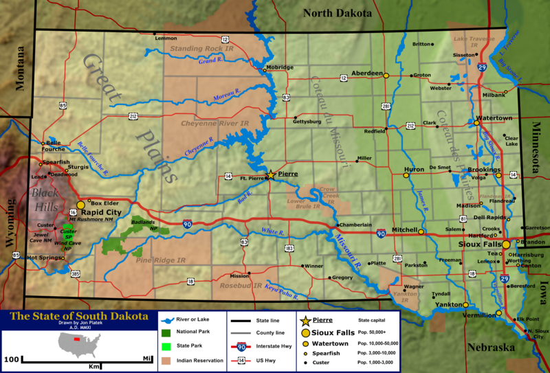
English: General map of the US state of South Dakota. Shown are the state's topography, major cities and roads, boundaries, and bodies of water. |
| Petsa | |
| Gigikanan | Base topography map is from the public domain National Atlas, as were several layers used as reference points. Highway shields were by User:SPUI and released to the public domain. US locator map was by User:Theshibboleth. All other work was done by the uploader. |
| Tagsulat | Jon Platek. |
Pagtugot
I, the copyright holder of this work, hereby publish it under the following licenses:
This file is licensed under the Creative Commons Attribution-Share Alike 3.0 Unported license.
- Libre ka:
- sa pagsabwag – sa pagkopya, pag-apod-apod ug pagsabwag sa hinimo
- sa pag-remix – sa pag-adap sa binuhat
- Ubos sa mosunod nga mga kondisyon:
- atribusyon – Kinahanglan nimo nga hatagan ang angay nga kredito, maghatag usa ka link sa lisensya, ug ipakita kung adunay mga pagbag-o. Mahimo nimo kini buhaton sa bisan unsang makatarunganon nga paagi, apan dili sa bisan unsang paagi nga nagsugyot nga gi-endorso ka sa licensor o ang imong paggamit.
- share parehas – Kung imong gi-remix, gibag-o, o gibase sa materyal, kinahanglan nimo nga iapod-apod ang imong mga kontribusyon sa ilawom sa parehas o katugma nga lisensya sama sa orihinal.

|
Gitugot ang pagkopya, pag-apud-apod o/ug pag-usab ning maong dokumento ubos sa mga termino sa GNU Free Documentation License, Version 1.2 o mas bag-ong bersiyon nga gimantala sa Free Software Foundation; nga walay Invariant Sections, walay Front-Cover Texts, ug walay Back-Cover Texts. Ang kopya sa lisensiya gilakip sa bahin nga giulohang GNU Free Documentation License. |
You may select the license of your choice.
Kaagi sa payl
I-klik ang petsa/oras aron makit-an ang hulagway sa payl niadtong panahona.
| Petsa/Takna | Thumbnail | Mga dimensyon | Tiggamit | Komento | |
|---|---|---|---|---|---|
| kasamtangan | 18:04, 25 Enero 2011 | | 2,254 × 1,531 (3.71 MB) | AlexiusHoratius~commonswiki | forgot to label Volga |
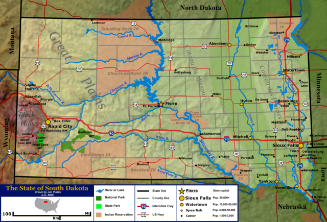
| 16:59, 25 Enero 2011 |  | 2,254 × 1,531 (3.71 MB) | AlexiusHoratius~commonswiki | {{Information |Description ={{en|1=General map of the US state of South Dakota. Shown are the state's topography, major cities and roads, boundaries, and bodies of water.}} |Source ={{own}} |Author =[[User:AlexiusHoratius|AlexiusHoratiu |
Mga paggamit sa payl
Ang mosunod nga mga panid misumpay niining payl:
Global nga paggamit sa payl
Kining ubang wiki naggamit ning maong payl:
- Paggamit sa bn.wikipedia.org
- Paggamit sa ca.wikipedia.org
- Paggamit sa en.wikipedia.org
- Paggamit sa es.wikipedia.org
- Paggamit sa id.wikipedia.org
- Paggamit sa ja.wikipedia.org
- Paggamit sa ko.wikipedia.org
- Paggamit sa lb.wikipedia.org
- Paggamit sa no.wikipedia.org
- Paggamit sa zh.wikipedia.org