Payl:South over the Quiraing, Isle of Skye - 2.jpg

Gidak-on ning maong paunang tan-aw: 800 x 400 ka mga piksel. Uban pang mga resoluyon: 320 x 160 ka mga piksel | 640 x 320 ka mga piksel | 1,024 x 512 ka mga piksel | 1,280 x 640 ka mga piksel | 2,560 x 1,280 ka mga piksel | 6,000 x 3,000 ka mga piksel.
Tibuok resolusyon (6,000 × 3,000 pixels, size sa payl: 6.73 MB, MIME type: image/jpeg)
Mubong sugid:
| Deskripsyon |
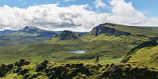
English: Looking South over the Quiraing on the Isle of Skye.
|
| Petsa | |
| Gigikanan | Kaugalingong trabaho |
| Tagsulat | Colin |
| Attribution (required by the license) | © User:Colin / Wikimedia Commons / |
|
| Camera location | | View this and other nearby images on: OpenStreetMap |
|---|
Pagtugot
I, the copyright holder of this work, hereby publish it under the following license:
This file is licensed under the Creative Commons Attribution-Share Alike 4.0 International license.
- Libre ka:
- sa pagsabwag – sa pagkopya, pag-apod-apod ug pagsabwag sa hinimo
- sa pag-remix – sa pag-adap sa binuhat
- Ubos sa mosunod nga mga kondisyon:
- atribusyon – Kinahanglan nimo nga hatagan ang angay nga kredito, maghatag usa ka link sa lisensya, ug ipakita kung adunay mga pagbag-o. Mahimo nimo kini buhaton sa bisan unsang makatarunganon nga paagi, apan dili sa bisan unsang paagi nga nagsugyot nga gi-endorso ka sa licensor o ang imong paggamit.
- share parehas – Kung imong gi-remix, gibag-o, o gibase sa materyal, kinahanglan nimo nga iapod-apod ang imong mga kontribusyon sa ilawom sa parehas o katugma nga lisensya sama sa orihinal.
Kaagi sa payl
I-klik ang petsa/oras aron makit-an ang hulagway sa payl niadtong panahona.
| Petsa/Takna | Thumbnail | Mga dimensyon | Tiggamit | Komento | |
|---|---|---|---|---|---|
| kasamtangan | 14:17, 31 Agosto 2015 | | 6,000 × 3,000 (6.73 MB) | Colin | User created page with UploadWizard |
Mga paggamit sa payl
Ang mosunod nga mga panid misumpay niining payl:
Global nga paggamit sa payl
Kining ubang wiki naggamit ning maong payl:
- Paggamit sa ar.wikipedia.org
- Paggamit sa ast.wikipedia.org
- Paggamit sa ca.wikipedia.org
- Paggamit sa cy.wikipedia.org
- Paggamit sa de.wikipedia.org
- Paggamit sa de.wikivoyage.org
- Paggamit sa eu.wikipedia.org
- Paggamit sa fr.wikipedia.org
- Paggamit sa fr.wikivoyage.org
- Paggamit sa ga.wikipedia.org
- Paggamit sa no.wikipedia.org
- Paggamit sa sv.wikipedia.org
- Paggamit sa uk.wikipedia.org
- Paggamit sa vi.wikipedia.org
- Paggamit sa www.wikidata.org