Payl:St. Johns, Arizona (101310387).jpg

Tibuok resolusyon (1,600 × 1,200 pixels, size sa payl: 610 KB, MIME type: image/jpeg)
.jpg)
Mubong sugid:
| Deskripsyon |
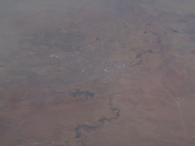
St. Johns is the only city in and the county seat of Apache County, Arizona, United States. It is located along U.S. Route 180, mostly west of where that highway intersects with U.S. Route 191. According to 2006 Census Bureau estimates, the population of the city was 3,538. St. Johns was first settled in 1873 by the Barth Brothers. They were bought out in 1879 by Ammon M. Tenney. St. Johns has been the county seat for almost all of the county's history. When the county was created on February 24, 1879, Snowflake was designated the county seat. After the first election in fall 1879, county government was set up in St. Johns, though it was moved again in 1880, to Springerville; in 1882 St. Johns again became the county seat, and it has remained so ever since. St. Johns is home to the Apache County Historical Society Museum and has four National Register of Historic Places: Isaacson Building, Lower Zuni River Archeological District, Lyman Lake Rock Art Site, and Rattlesnake Point Pueblo. St. Johns is near the Placerias Quarry, the site where dozens of Placerias fossils were discovered in 1930 by Charles Camp and Samuel Welles, of the University of California, Berkeley. St. Johns is along the shortest and most scenic route from Phoenix to Albuquerque, New Mexico. Within an hour's drive from St. John's are Apache-Sitgreaves National Forest, Petrified Forest National Park, the Painted Desert, and Lyman Lake State Park, as well as Indian reservations such as the Navajo Nation, Fort Apache Indian Reservation, San Carlos Apache Indian Reservation, and Zuni Indian Reservation. en.wikipedia.org/wiki/St._Johns,_Arizona en.wikipedia.org/wiki/Wikipedia:Text_of_Creative_Commons_... |
| Petsa | |
| Gigikanan | St. Johns, Arizona |
| Tagsulat | Ken Lund from Reno, Nevada, USA |
| Camera location | | View this and other nearby images on: OpenStreetMap |
|---|
.jpg¶ms=034.506910_N_-109.361858_E_globe:Earth_type:camera_source:Flickr_&language=ceb)
Pagtugot
- Libre ka:
- sa pagsabwag – sa pagkopya, pag-apod-apod ug pagsabwag sa hinimo
- sa pag-remix – sa pag-adap sa binuhat
- Ubos sa mosunod nga mga kondisyon:
- atribusyon – Kinahanglan nimo nga hatagan ang angay nga kredito, maghatag usa ka link sa lisensya, ug ipakita kung adunay mga pagbag-o. Mahimo nimo kini buhaton sa bisan unsang makatarunganon nga paagi, apan dili sa bisan unsang paagi nga nagsugyot nga gi-endorso ka sa licensor o ang imong paggamit.
- share parehas – Kung imong gi-remix, gibag-o, o gibase sa materyal, kinahanglan nimo nga iapod-apod ang imong mga kontribusyon sa ilawom sa parehas o katugma nga lisensya sama sa orihinal.
| This image was originally posted to Flickr by Ken Lund at https://flickr.com/photos/75683070@N00/101310387. It was reviewed on 3 Disyembre 2015 by FlickreviewR and was confirmed to be licensed under the terms of the cc-by-sa-2.0. |
Kaagi sa payl
I-klik ang petsa/oras aron makit-an ang hulagway sa payl niadtong panahona.
| Petsa/Takna | Thumbnail | Mga dimensyon | Tiggamit | Komento | |
|---|---|---|---|---|---|
| kasamtangan | 21:43, 3 Disyembre 2015 | | 1,600 × 1,200 (610 KB) | INeverCry | Transferred from Flickr via Flickr2Commons |
Mga paggamit sa payl
Ang mosunod nga mga panid misumpay niining payl:
Global nga paggamit sa payl
Kining ubang wiki naggamit ning maong payl:
- Paggamit sa ar.wikipedia.org
- Paggamit sa arz.wikipedia.org
- Paggamit sa bg.wikipedia.org
- Paggamit sa ca.wikipedia.org
- Paggamit sa ce.wikipedia.org
- Paggamit sa cy.wikipedia.org
- Paggamit sa es.wikipedia.org
- Paggamit sa eu.wikipedia.org
- Paggamit sa he.wikipedia.org
- Paggamit sa ht.wikipedia.org
- Paggamit sa hu.wikipedia.org
- Paggamit sa it.wikipedia.org
- Paggamit sa lld.wikipedia.org
- Paggamit sa no.wikipedia.org
- Paggamit sa pl.wikipedia.org
- Paggamit sa pt.wikipedia.org
- Paggamit sa ro.wikipedia.org
- Paggamit sa sr.wikipedia.org
- Paggamit sa tt.wikipedia.org
- Paggamit sa uz.wikipedia.org
- Paggamit sa vo.wikipedia.org
- Paggamit sa www.wikidata.org
.jpg)