Payl:St Mark, Amcotts - geograph.org.uk - 423061.jpg
Walay mas taas nga resolusyon.
St_Mark,_Amcotts_-_geograph.org.uk_-_423061.jpg (640 × 480 pixels, size sa payl: 70 KB, MIME type: image/jpeg)
Mubong sugid:
| Deskripsyon |
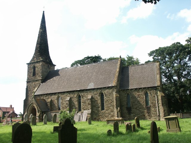
English: St Mark, Amcotts Standing near Flixborough and by the River Trent, the church of St Mark was built in the 1850s. The present building is the third to be built on the site. The foundation stone was laid on Tuesday 22nd October 1850 and was completed and dedicated to St Mark a year later, although the exact date is unknown. On 1st June 1974 the church was badly damaged with the Nypro explosion at Flixborough when the blast lifted the roof and dropped it again leaving a gap of 8 inches at the apex. The stained glass east window was completely blown in, there were cracks in the outer walls and it looked as though the church may have to be pulled down. Restoration did take place and although it also meant remaking the east window, the work was completed in two years. |
| Petsa | |
| Gigikanan | From geograph.org.uk |
| Tagsulat | Dave Hitchborne |
| Attribution (required by the license) | Dave Hitchborne / St Mark, Amcotts / |
| Camera location | | View this and other nearby images on: OpenStreetMap |
|---|
_heading:315.00&language=ceb)
| Object location | | View this and other nearby images on: OpenStreetMap |
|---|
_heading:315.00&language=ceb)
Pagtugot

|
This image was taken from the Geograph project collection. See this photograph's page on the Geograph website for the photographer's contact details. The copyright on this image is owned by Dave Hitchborne and is licensed for reuse under the Creative Commons Attribution-ShareAlike 2.0 license.
|
This file is licensed under the Creative Commons Attribution-Share Alike 2.0 Generic license.
Attribution: Dave Hitchborne
- Libre ka:
- sa pagsabwag – sa pagkopya, pag-apod-apod ug pagsabwag sa hinimo
- sa pag-remix – sa pag-adap sa binuhat
- Ubos sa mosunod nga mga kondisyon:
- atribusyon – Kinahanglan nimo nga hatagan ang angay nga kredito, maghatag usa ka link sa lisensya, ug ipakita kung adunay mga pagbag-o. Mahimo nimo kini buhaton sa bisan unsang makatarunganon nga paagi, apan dili sa bisan unsang paagi nga nagsugyot nga gi-endorso ka sa licensor o ang imong paggamit.
- share parehas – Kung imong gi-remix, gibag-o, o gibase sa materyal, kinahanglan nimo nga iapod-apod ang imong mga kontribusyon sa ilawom sa parehas o katugma nga lisensya sama sa orihinal.
Kaagi sa payl
I-klik ang petsa/oras aron makit-an ang hulagway sa payl niadtong panahona.
| Petsa/Takna | Thumbnail | Mga dimensyon | Tiggamit | Komento | |
|---|---|---|---|---|---|
| kasamtangan | 05:35, 4 Pebrero 2011 | | 640 × 480 (70 KB) | GeographBot | == {{int:filedesc}} == {{Information |description={{en|1=St Mark, Amcotts Standing near Flixborough and by the River Trent, the church of St Mark was built in the 1850s. The present building is the third to be built on the site. The foundation stone was |
Mga paggamit sa payl
Ang mosunod nga mga panid misumpay niining payl:
Global nga paggamit sa payl
Kining ubang wiki naggamit ning maong payl: