Payl:SuluRangeNASA.jpg
Walay mas taas nga resolusyon.
SuluRangeNASA.jpg (640 × 422 pixels, size sa payl: 57 KB, MIME type: image/jpeg)
Mubong sugid:
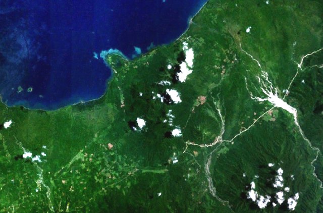
| Deskripsyon | Forested volcanoes of the Sulu Range occupy the center of this NASA Landsat image (with north to the top) of west-central New Britain. This group of partially overlapping small stratovolcanoes and lava domes off Bangula Bay reaches heights of about 600 m. Mount Karai, also known as Mount Ruckenberg, lies on the NE side of the geochemically diverse, basaltic-to-rhyolitic complex. Kaiamu maar forms the peninsula extending about 1 km into Bangula Bay at the NW side of the Sulu Range. | |||||
| Petsa | Unknown date | |||||
| Gigikanan | http://www.volcano.si.edu/world/volcano.cfm?vnum=0502-09= | |||||
| Tagsulat | NASA Landsat7 image (worldwind.arc.nasa.gov) | |||||
| Pagtugot (Paggamit pag-usab niini nga file) |
|
|||||
| Location | New Britain, Papua New Guinea |

Kaagi sa payl
I-klik ang petsa/oras aron makit-an ang hulagway sa payl niadtong panahona.
| Petsa/Takna | Thumbnail | Mga dimensyon | Tiggamit | Komento | |
|---|---|---|---|---|---|
| kasamtangan | 04:58, 22 Abril 2007 | | 640 × 422 (57 KB) | Seattle Skier | == Summary == {{Information |Description= Forested volcanoes of the Sulu Range occupy the center of this NASA Landsat image of west-central New Britain (north to the top). Papua New Guinea |Source= http://www.volcano.si.edu/world/volca |
Mga paggamit sa payl
Ang mosunod nga mga panid misumpay niining payl:
Global nga paggamit sa payl
Kining ubang wiki naggamit ning maong payl:
- Paggamit sa als.wikipedia.org
- Paggamit sa arz.wikipedia.org
- Paggamit sa de.wikipedia.org
- Paggamit sa en.wikipedia.org
- Paggamit sa www.wikidata.org