Payl:Tibet Karte Topograpisch.png
Gidak-on ning maong paunang tan-aw: 800 x 540 ka mga piksel. Uban pang mga resoluyon: 320 x 216 ka mga piksel | 640 x 432 ka mga piksel | 1,024 x 691 ka mga piksel | 1,500 x 1,012 ka mga piksel.
Tibuok resolusyon (1,500 × 1,012 pixels, size sa payl: 3.08 MB, MIME type: image/png)
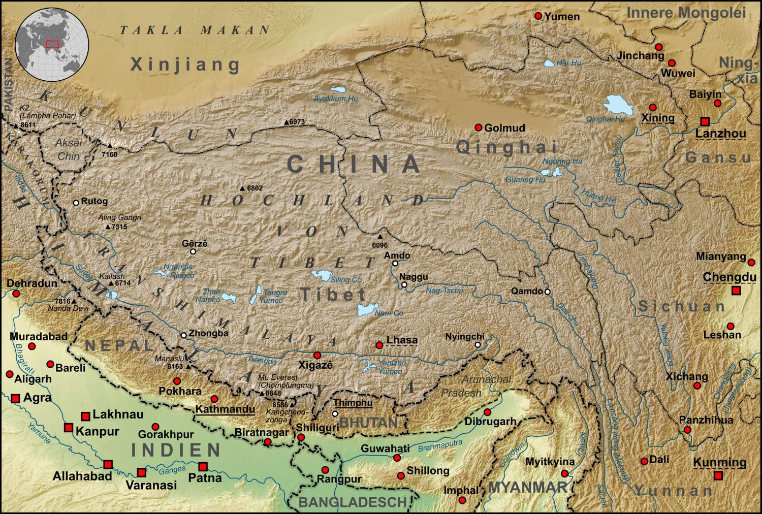
| Deskripsyon | Topographische Karte der chinesischen autonomen Provinz Tibet, sowie der umliegenden chinesischen Provinzen und der angrenzenden Länder |
| Petsa | |
| Gigikanan |
own work, used:
|
| Tagsulat | Lencer |
| Other versions | Derivative works of this file: ZabuyeLake1.png |
This file is licensed under the Creative Commons Attribution-Share Alike 3.0 Unported license.
- Libre ka:
- sa pagsabwag – sa pagkopya, pag-apod-apod ug pagsabwag sa hinimo
- sa pag-remix – sa pag-adap sa binuhat
- Ubos sa mosunod nga mga kondisyon:
- atribusyon – Kinahanglan nimo nga hatagan ang angay nga kredito, maghatag usa ka link sa lisensya, ug ipakita kung adunay mga pagbag-o. Mahimo nimo kini buhaton sa bisan unsang makatarunganon nga paagi, apan dili sa bisan unsang paagi nga nagsugyot nga gi-endorso ka sa licensor o ang imong paggamit.
- share parehas – Kung imong gi-remix, gibag-o, o gibase sa materyal, kinahanglan nimo nga iapod-apod ang imong mga kontribusyon sa ilawom sa parehas o katugma nga lisensya sama sa orihinal.

|
This map has been made or improved in the German Kartenwerkstatt (Map Lab). You can propose maps to improve as well.
|
Kaagi sa payl
I-klik ang petsa/oras aron makit-an ang hulagway sa payl niadtong panahona.
| Petsa/Takna | Thumbnail | Mga dimensyon | Tiggamit | Komento | |
|---|---|---|---|---|---|
| kasamtangan | 06:30, 28 Oktubre 2015 | | 1,500 × 1,012 (3.08 MB) | Lencer | Ulugh Muztagh now 6973 m |
| 06:30, 28 Oktubre 2015 |  | 3,240 × 2,185 (12.63 MB) | Lencer | Ulugh Muztagh now 6973 m | |
| 13:11, 1 Marso 2009 |  | 1,500 × 1,012 (3.11 MB) | Lencer | Einige Korrekturen und Ergänzungen | |
| 21:22, 12 Disyembre 2008 |  | 1,500 × 1,012 (3.11 MB) | Lencer | {{Information |Description= |Source= |Date= |Author= |Permission= |other_versions= }} | |
| 08:18, 12 Disyembre 2008 |  | 1,500 × 1,012 (3.11 MB) | Lencer | {{Information |Description= |Source= |Date= |Author= |Permission= |other_versions= }} | |
| 12:57, 11 Disyembre 2008 |  | 1,500 × 1,012 (3.11 MB) | Lencer | {{Information |Description= |Source= |Date= |Author= |Permission= |other_versions= }} | |
| 12:13, 22 Nobiyembre 2008 |  | 1,500 × 1,012 (3.1 MB) | Lencer | {{Information |Description= |Source= |Date= |Author= |Permission= |other_versions= }} | |
| 14:46, 16 Nobiyembre 2008 |  | 1,500 × 1,012 (3.09 MB) | Lencer | {{Information| |Description=Topograhische Karte der chinesischen autonomen Provinz Tibet, sowie der umliegenden chinesischen Provinzen und der angrenzenden Länder |Source=own work, used: * Generic Mapping Tools and SRTM30-fi |
Mga paggamit sa payl
Ang mosunod nga 2 panid misumpay niining payl:
Global nga paggamit sa payl
Kining ubang wiki naggamit ning maong payl:
- Paggamit sa af.wikipedia.org
- Paggamit sa ar.wikipedia.org
- Paggamit sa ast.wikipedia.org
- Paggamit sa az.wikipedia.org
- Paggamit sa bo.wikipedia.org
- Paggamit sa ca.wikipedia.org
- Paggamit sa ckb.wikipedia.org
- Paggamit sa de.wikipedia.org
- Kunlun
- Transhimalaya
- Autonomes Gebiet Tibet
- Diskussion:Karakorum (Gebirge)
- Hochland von Tibet
- Benutzer:Lencer
- Benutzer:Lencer/Galerie
- Wikipedia:Kartenwerkstatt/Archiv/2008-12
- Diskussion:Transhimalaya
- Wikipedia Diskussion:Hauptseite/Artikel des Tages/Archiv/Vorschläge/2013/Q1
- Wikipedia:Hauptseite/Archiv/14. Februar 2013
- Tibet (1912–1951)
- Pinjarra-Orogen
- Tektonische Entwicklung des indischen Subkontinents
- Geologie des Transhimalayas
- Geologie der Indus-Yarlung suture zone
- Paggamit sa el.wikipedia.org
- Paggamit sa en.wikipedia.org
- Paggamit sa eo.wikipedia.org
- Paggamit sa es.wikipedia.org
- Paggamit sa eu.wikipedia.org
- Paggamit sa fi.wikipedia.org
- Paggamit sa frr.wikipedia.org
- Paggamit sa fr.wikipedia.org
- Paggamit sa ga.wikipedia.org
- Paggamit sa gl.wikipedia.org
- Paggamit sa he.wikivoyage.org
- Paggamit sa hi.wikipedia.org
- Paggamit sa hu.wikipedia.org
- Paggamit sa hy.wikipedia.org
- Paggamit sa it.wikipedia.org
- Paggamit sa ja.wikipedia.org
- Paggamit sa ku.wikipedia.org
- Paggamit sa lld.wikipedia.org
- Paggamit sa lt.wikipedia.org
View more global usage of this file.