Payl:Topographic map of Buru-en.svg

Size of this PNG preview of this SVG file: 800 x 598 ka mga piksel. Uban pang mga resoluyon: 320 x 239 ka mga piksel | 640 x 479 ka mga piksel | 1,024 x 766 ka mga piksel | 1,280 x 957 ka mga piksel | 2,560 x 1,915 ka mga piksel | 1,972 x 1,475 ka mga piksel.
Tibuok resolusyon (SVG nga payl, nominally 1,972 × 1,475 pixels, size sa payl: 1.14 MB)
Mubong sugid:
| Deskripsyon |
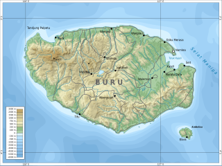
English: Topographic map of Buru.
Bahasa Indonesia: Peta topografi Pulau Buru. |
| Petsa | |
| Gigikanan |
Kaugalingong trabaho. Self-made in Inkscape and GIMP.
|
| Tagsulat | Oona Räisänen |
| Other versions |
Derivative works of this file: |
| SVG genesis |
Pagtugot
I, the copyright holder of this work, hereby publish it under the following licenses:
This file is licensed under the Creative Commons Attribution-Share Alike 3.0 Unported license.
- Libre ka:
- sa pagsabwag – sa pagkopya, pag-apod-apod ug pagsabwag sa hinimo
- sa pag-remix – sa pag-adap sa binuhat
- Ubos sa mosunod nga mga kondisyon:
- atribusyon – Kinahanglan nimo nga hatagan ang angay nga kredito, maghatag usa ka link sa lisensya, ug ipakita kung adunay mga pagbag-o. Mahimo nimo kini buhaton sa bisan unsang makatarunganon nga paagi, apan dili sa bisan unsang paagi nga nagsugyot nga gi-endorso ka sa licensor o ang imong paggamit.
- share parehas – Kung imong gi-remix, gibag-o, o gibase sa materyal, kinahanglan nimo nga iapod-apod ang imong mga kontribusyon sa ilawom sa parehas o katugma nga lisensya sama sa orihinal.

|
Gitugot ang pagkopya, pag-apud-apod o/ug pag-usab ning maong dokumento ubos sa mga termino sa GNU Free Documentation License, Version 1.2 o mas bag-ong bersiyon nga gimantala sa Free Software Foundation; nga walay Invariant Sections, walay Front-Cover Texts, ug walay Back-Cover Texts. Ang kopya sa lisensiya gilakip sa bahin nga giulohang GNU Free Documentation License. |
You may select the license of your choice.
Kaagi sa payl
I-klik ang petsa/oras aron makit-an ang hulagway sa payl niadtong panahona.
| Petsa/Takna | Thumbnail | Mga dimensyon | Tiggamit | Komento | |
|---|---|---|---|---|---|
| kasamtangan | 08:51, 16 Abril 2011 | | 1,972 × 1,475 (1.14 MB) | Mysid | remove unnamed town dots |
| 14:34, 12 Abril 2011 |  | 1,972 × 1,475 (1.14 MB) | Mysid | bugfix #2 | |
| 14:33, 12 Abril 2011 |  | 1,972 × 1,475 (1.14 MB) | Mysid | bugfix #1 | |
| 14:31, 12 Abril 2011 |  | 1,972 × 1,475 (1.14 MB) | Mysid | {{Information |Description ={{en|1=Topographic map of Buru.}} |Source ={{own}}. Self-made in Inkscape and GIMP. |Author =Mysid |Date =2010-04-12 |Permission = |other_versions = }} [[Category |
Mga paggamit sa payl
Ang mosunod nga mga panid misumpay niining payl:
Global nga paggamit sa payl
Kining ubang wiki naggamit ning maong payl:
- Paggamit sa ar.wikipedia.org
- Paggamit sa arz.wikipedia.org
- Paggamit sa az.wikipedia.org
- İstifadəçi müzakirəsi:Cekli829
- İstifadəçi müzakirəsi:Namikilisu
- İstifadəçi müzakirəsi:Firuza
- İstifadəçi müzakirəsi:Qızılbaş
- İstifadəçi müzakirəsi:Rəşid Nurməmmədov
- İstifadəçi müzakirəsi:Vüsal
- İstifadəçi müzakirəsi:Anar kerimxanov
- İstifadəçi müzakirəsi:Natəvan.R.
- İstifadəçi müzakirəsi:CalalC99
- Vikipediya:Həftənin seçilmiş məqaləsi/mart 2019
- Vikipediya:Həftənin seçilmiş məqaləsi/13. Həftə 2019
- İstifadəçi müzakirəsi:Araz Yaquboglu/Arxiv 10
- İstifadəçi müzakirəsi:Turkmen/Arxiv 4
- İstifadəçi müzakirəsi:Masalli qasimli/Arxiv 5
- İstifadəçi müzakirəsi:White Demon/Arxiv 6
- Paggamit sa be.wikipedia.org
- Paggamit sa bg.wikipedia.org
- Paggamit sa br.wikipedia.org
- Paggamit sa ca.wikipedia.org
- Paggamit sa cy.wikipedia.org
- Paggamit sa de.wikipedia.org
- Paggamit sa el.wikipedia.org
- Paggamit sa en.wikipedia.org
- Paggamit sa en.wikivoyage.org
- Paggamit sa eo.wikipedia.org
- Paggamit sa es.wikipedia.org
- Paggamit sa eu.wikipedia.org
- Paggamit sa fa.wikipedia.org
- Paggamit sa fi.wikipedia.org
- Paggamit sa fr.wikipedia.org
- Paggamit sa id.wikipedia.org
- Paggamit sa incubator.wikimedia.org
- Paggamit sa lv.wikipedia.org
- Paggamit sa ms.wikipedia.org
- Paggamit sa nl.wikipedia.org
- Paggamit sa nn.wikipedia.org
- Paggamit sa no.wikipedia.org
View more global usage of this file.