Payl:Topographic map of the Kai Islands-en.svg

Size of this PNG preview of this SVG file: 800 x 573 ka mga piksel. Uban pang mga resoluyon: 320 x 229 ka mga piksel | 640 x 459 ka mga piksel | 1,024 x 734 ka mga piksel | 1,280 x 917 ka mga piksel | 2,560 x 1,834 ka mga piksel | 1,753 x 1,256 ka mga piksel.
Tibuok resolusyon (SVG nga payl, nominally 1,753 × 1,256 pixels, size sa payl: 492 KB)
Mubong sugid:
| Deskripsyon |
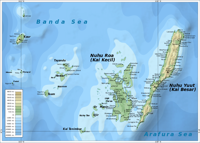
English: Map of the Kai Islands. |
| Petsa | |
| Gigikanan |
Kaugalingong trabaho – self-made in Inkscape.
|
| Tagsulat | Oona Räisänen (Mysid) |
Pagtugot
I, the copyright holder of this work, hereby publish it under the following licenses:
This file is licensed under the Creative Commons Attribution-Share Alike 3.0 Unported license.
- Libre ka:
- sa pagsabwag – sa pagkopya, pag-apod-apod ug pagsabwag sa hinimo
- sa pag-remix – sa pag-adap sa binuhat
- Ubos sa mosunod nga mga kondisyon:
- atribusyon – Kinahanglan nimo nga hatagan ang angay nga kredito, maghatag usa ka link sa lisensya, ug ipakita kung adunay mga pagbag-o. Mahimo nimo kini buhaton sa bisan unsang makatarunganon nga paagi, apan dili sa bisan unsang paagi nga nagsugyot nga gi-endorso ka sa licensor o ang imong paggamit.
- share parehas – Kung imong gi-remix, gibag-o, o gibase sa materyal, kinahanglan nimo nga iapod-apod ang imong mga kontribusyon sa ilawom sa parehas o katugma nga lisensya sama sa orihinal.

|
Gitugot ang pagkopya, pag-apud-apod o/ug pag-usab ning maong dokumento ubos sa mga termino sa GNU Free Documentation License, Version 1.2 o mas bag-ong bersiyon nga gimantala sa Free Software Foundation; nga walay Invariant Sections, walay Front-Cover Texts, ug walay Back-Cover Texts. Ang kopya sa lisensiya gilakip sa bahin nga giulohang GNU Free Documentation License. |
You may select the license of your choice.
Kaagi sa payl
I-klik ang petsa/oras aron makit-an ang hulagway sa payl niadtong panahona.
| Petsa/Takna | Thumbnail | Mga dimensyon | Tiggamit | Komento | |
|---|---|---|---|---|---|
| kasamtangan | 07:45, 18 Abril 2011 | | 1,753 × 1,256 (492 KB) | Mysid | {{Information |Description ={{en|1=Map of the Kai Islands.}} |Source ={{own}} – self-made in Inkscape |Author =Mysid |Date =2010-10-18 |Permission = |other_versions = }} [[Category: |
Mga paggamit sa payl
Ang mosunod nga 15 panid misumpay niining payl:
Global nga paggamit sa payl
Kining ubang wiki naggamit ning maong payl:
- Paggamit sa ar.wikipedia.org
- Paggamit sa ast.wikipedia.org
- Paggamit sa bg.wikipedia.org
- Paggamit sa ca.wikipedia.org
- Paggamit sa de.wikipedia.org
- Paggamit sa en.wikipedia.org
- Paggamit sa en.wikivoyage.org
- Paggamit sa eo.wikipedia.org
- Paggamit sa es.wikipedia.org
- Paggamit sa eu.wikipedia.org
- Paggamit sa fr.wikipedia.org
- Paggamit sa fr.wikivoyage.org
- Paggamit sa gl.wikipedia.org
- Paggamit sa id.wikipedia.org
- Paggamit sa ilo.wikipedia.org
View more global usage of this file.