Payl:Tuvalu location map.svg

Tibuok resolusyon (SVG nga payl, nominally 532 × 673 pixels, size sa payl: 16 KB)
Mubong sugid:
| Deskripsyon |
Deutsch: Positionskarte von Tuvalu
Quadratische Plattkarte. Geographische Begrenzung der Karte:
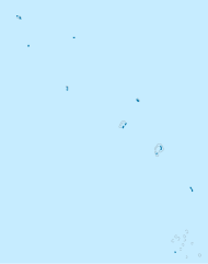
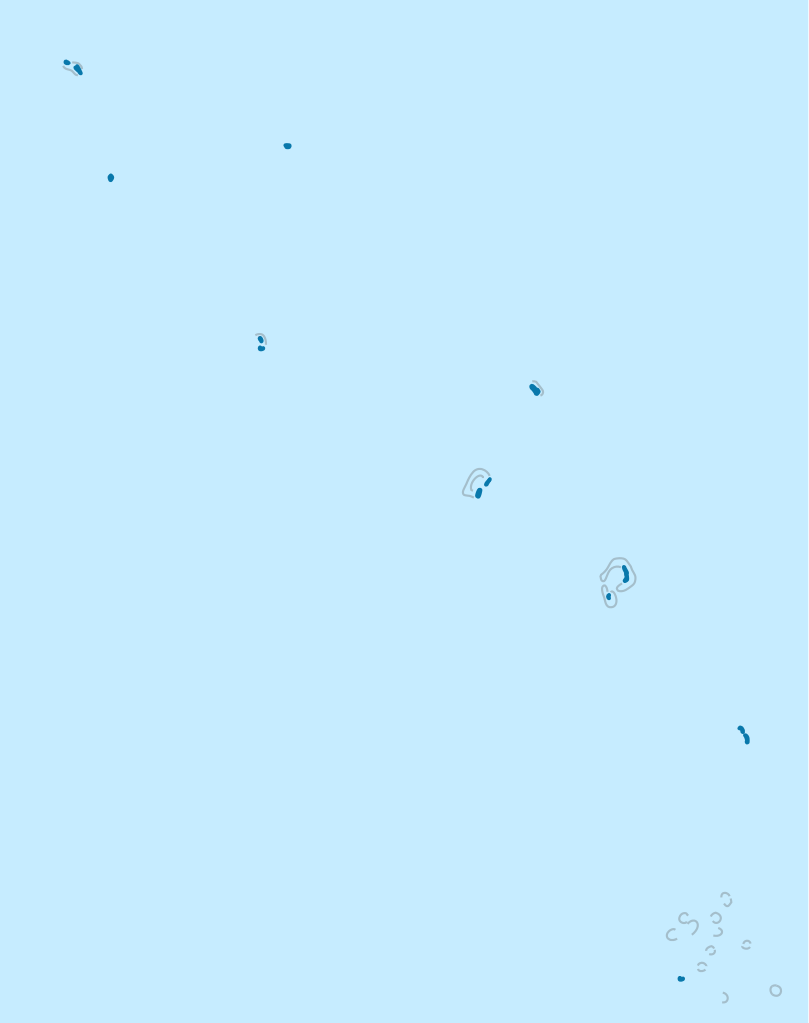
English: Location map of Tuvalu
Equirectangular projection. Geographic limits of the map:
|
|
| Petsa | ||
| Gigikanan |
Kaugalingong trabaho, using
|
|
| Tagsulat | NordNordWest | |
| Pagtugot (Paggamit pag-usab niini nga file) |
This file is licensed under the Creative Commons Attribution-Share Alike 3.0 Germany license.
 This file is licensed under the Creative Commons Attribution-Share Alike 3.0 Germany license.
|


|
This map has been made or improved in the German Kartenwerkstatt (Map Lab). You can propose maps to improve as well.
|
Kaagi sa payl
I-klik ang petsa/oras aron makit-an ang hulagway sa payl niadtong panahona.
| Petsa/Takna | Thumbnail | Mga dimensyon | Tiggamit | Komento | |
|---|---|---|---|---|---|
| kasamtangan | 16:41, 26 Agosto 2011 | | 532 × 673 (16 KB) | Convallaria majalis | looks like a smaller copy of this file is damaged... |
| 11:30, 19 Nobiyembre 2009 |  | 532 × 673 (16 KB) | NordNordWest | == {{int:filedesc}} == {{Information |Description= {{de|Positionskarte von Tuvalu}} Quadratische Plattkarte. Geographische Begrenzung der Karte: * N: 5.3° S * S: 11.0° S * W: 175.7° O * O: 179.8° W {{en|Location map of [[:en:Tuvalu|Tuva |
Mga paggamit sa payl
Ang mosunod nga 46 panid misumpay niining payl:
- Asia (pagklaro)
- Aula
- Bayonnaise Seamount
- Blasted Boat Pass
- Coal Island
- Egg Island
- Ellice Group
- Entrance Island
- Fale
- Fongafale
- Funafuti
- Hudson Island
- Independence
- Lynx (pagklaro)
- Mangrove Swamp
- Mangrove Swamps
- Mitchell Island
- Mosana
- Motuloa
- Nanumanga
- Nanumea
- Niu
- Niulakita
- Niutao
- Nui
- Nui Island
- Nukufetau
- Nukulaelae
- Oua
- Pisonia Grandis Woodland
- Rocky Island
- Sand Islet
- Sophia Island
- Steep Fringing Reef
- Te Namo
- Te Papa
- Teafatule
- Tefala
- Telele
- Temotuloto
- Tepuka
- Tonga (pagklaro)
- Tracy Island
- Tuvalu (pagklaro)
- Vaitupu
- Plantilya:Location map Tuvalu
Global nga paggamit sa payl
Kining ubang wiki naggamit ning maong payl:
- Paggamit sa af.wikipedia.org
- Paggamit sa an.wikipedia.org
- Paggamit sa ar.wikipedia.org
- Paggamit sa ast.wikipedia.org
- Paggamit sa az.wikipedia.org
- Paggamit sa be-tarask.wikipedia.org
- Paggamit sa be.wikipedia.org
- Paggamit sa bg.wikipedia.org
- Paggamit sa bn.wikipedia.org
- Paggamit sa bs.wikipedia.org
- Paggamit sa ckb.wikipedia.org
- Paggamit sa crh.wikipedia.org
- Paggamit sa cs.wikipedia.org
- Paggamit sa da.wikipedia.org
- Paggamit sa de.wikipedia.org
View more global usage of this file.