Payl:USACE Depoe Bay Oregon.jpg

Gidak-on ning maong paunang tan-aw: 800 x 528 ka mga piksel. Uban pang mga resoluyon: 320 x 211 ka mga piksel | 640 x 422 ka mga piksel | 1,024 x 676 ka mga piksel | 1,500 x 990 ka mga piksel.
Tibuok resolusyon (1,500 × 990 pixels, size sa payl: 959 KB, MIME type: image/jpeg)
| Deskripsyon |
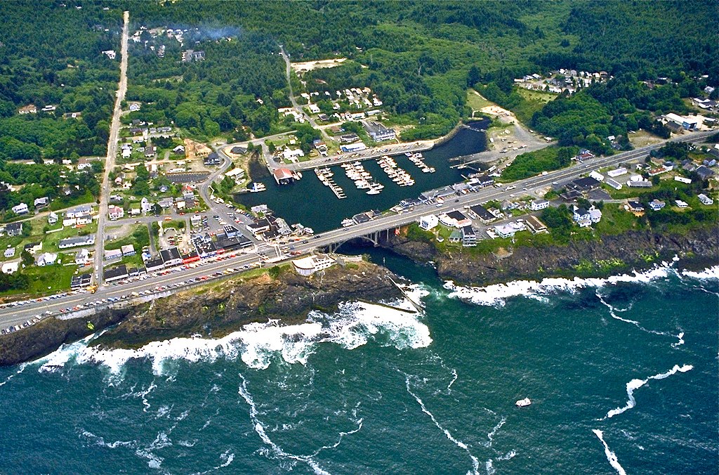
English: Aerial view of the harbor and center of Depoe Bay, Oregon, USA. |
|||
| Location | Depoe Bay, Oregon, USA 44°48′33.61″N 124°3′38.08″W / 44.8093361°N 124.0605778°W |
|||
| Petsa | ||||
| Gigikanan |
U.S. Army Corp of Engineers Digital Visual Library Digital Visual Library home page Image page Image description page |
|||
| Tagsulat | Bob Heims, U.S. Army Corps of Engineers | |||
| Pagtugot (Paggamit pag-usab niini nga file) |
|
Kaagi sa payl
I-klik ang petsa/oras aron makit-an ang hulagway sa payl niadtong panahona.
| Petsa/Takna | Thumbnail | Mga dimensyon | Tiggamit | Komento | |
|---|---|---|---|---|---|
| kasamtangan | 01:18, 24 Mayo 2012 | | 1,500 × 990 (959 KB) | Ian Page | Colour-enhanced version of original file |
| 02:54, 16 Abril 2007 |  | 1,500 × 990 (478 KB) | DanMS | {{Information2 | Description = {{en|Aerial view of the harbor and center of Depoe Bay, Oregon, USA.}} | Source = U.S. Army Corp of Engineers Digital Visual Library<br />[http://images.usace.army.mil/Main.html Digital Visual Library home page]<br />[h |
Mga paggamit sa payl
Ang mosunod nga mga panid misumpay niining payl:
Global nga paggamit sa payl
Kining ubang wiki naggamit ning maong payl:
- Paggamit sa ar.wikipedia.org
- Paggamit sa azb.wikipedia.org
- Paggamit sa bg.wikipedia.org
- Paggamit sa ca.wikipedia.org
- Paggamit sa ce.wikipedia.org
- Paggamit sa cs.wikipedia.org
- Paggamit sa cy.wikipedia.org
- Paggamit sa de.wikipedia.org
- Paggamit sa en.wikipedia.org
- Paggamit sa en.wikivoyage.org
- Paggamit sa es.wikipedia.org
- Paggamit sa eu.wikipedia.org
- Paggamit sa fa.wikipedia.org
- Paggamit sa fi.wikipedia.org
- Paggamit sa fr.wikipedia.org
- Paggamit sa ht.wikipedia.org
- Paggamit sa hu.wikipedia.org
- Paggamit sa it.wikipedia.org
- Paggamit sa ky.wikipedia.org
- Paggamit sa lld.wikipedia.org
- Paggamit sa pl.wikipedia.org
- Paggamit sa pt.wikipedia.org
- Paggamit sa sh.wikipedia.org
- Paggamit sa sr.wikipedia.org
- Paggamit sa tt.wikipedia.org
- Paggamit sa uk.wikipedia.org
- Paggamit sa uz.wikipedia.org
- Paggamit sa www.wikidata.org
- Paggamit sa zh-min-nan.wikipedia.org