Payl:Underwater mcmurdo sound.jpg
Tibuok resolusyon (1,867 × 1,400 pixels, size sa payl: 1.27 MB, MIME type: image/jpeg)
| Deskripsyon |
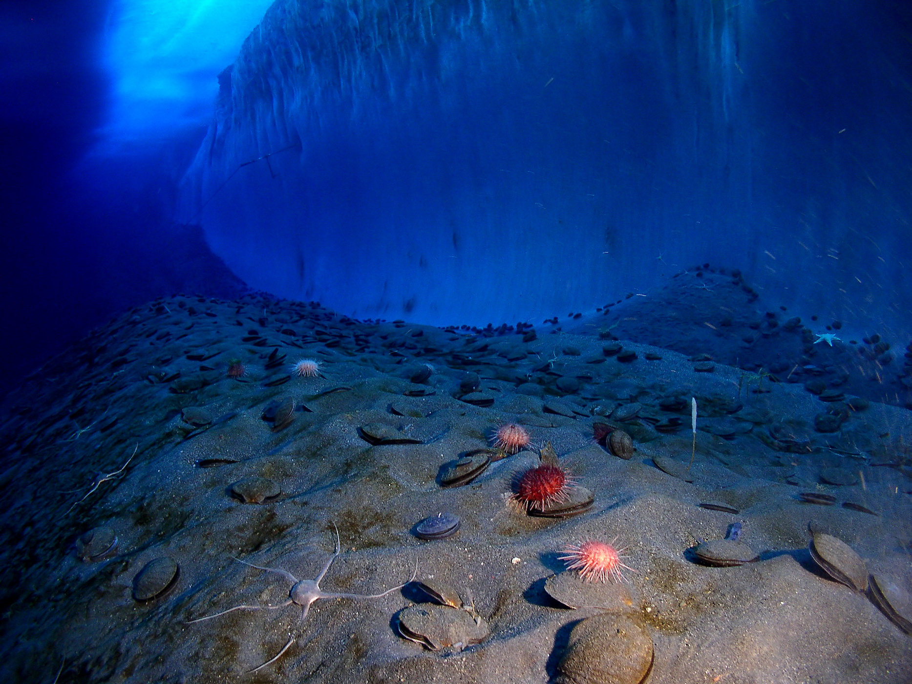
English: Image of an ice wall and the ocean floor adjacent to remote-controlled photographic equipment at Explorer's Cover, New Harbor, McMurdo Sound. An underwater camera is connected by cable to onshore facilities, which upload images to the Internet via radio signals.
main visible species : Français : Image d'un mur de glace d'une banquise à Explorer's Cover, New Harbor, Détroit de McMurdo, située non loin d'équipements photographiques commandés à distance. Un appareil photo est relié par un câble aux équipements à terre, qui téléchargent les photos vers internet par radio.
Principales espèces visibles : Deutsch: Dieser Bereich einer Eiswand und des Ozeanbodens bei Explorer's Cover, New Harbor, McMurdo-Sund grenzt an eine ferngesteuerte Foto-Anlage. Eine Unterwasser-Kamera ist mit Einrichtungen an Land verkabelt, die Bilder per Funk in das Internet übertragen.
Im Wesentlichen sind folgende Arten zu sehen:
日本語: 遠隔操作の撮影装置で撮影された南極マクマード湾ニューハーバーにあるExplorer's Coverの氷壁と海底の様子。水中カメラは陸上の施設とケーブルで繋がれており、そこからデータが無線で送信されインターネット上に画像が表示される仕組み。
写っている主な生物: Čeština: Podvodní fotografie ledovce a mořského dna v antarktické zátoce McMurdo. Na snímku jsou vidět:
|
| Petsa | |
| Gigikanan |
English-language Wikipedia (original image log here) |
| Tagsulat | NSF/USAP photo by Steve Clabuesch; uploaded by en:User:Fishdecoy |
| Pagtugot (Paggamit pag-usab niini nga file) |
PD-USGov |
| Camera location | | View this and other nearby images on: OpenStreetMap |
|---|
| This is a retouched picture, which means that it has been digitally altered from its original version. Modifications: noise reduction. Modifications made by Lycaon.
|
|

This image was selected as picture of the day on Vietnamese Wikipedia.
|
| This image is a work of a National Science Foundation employee, taken or made as part of that person's official duties. As a work of the U.S. federal government, the image is in the public domain. |  |
Kaagi sa payl
I-klik ang petsa/oras aron makit-an ang hulagway sa payl niadtong panahona.
| Petsa/Takna | Thumbnail | Mga dimensyon | Tiggamit | Komento | |
|---|---|---|---|---|---|
| kasamtangan | 17:17, 19 Enero 2008 | | 1,867 × 1,400 (1.27 MB) | Lycaon | better image |
| 15:40, 19 Enero 2008 |  | 1,396 × 1,044 (650 KB) | Lycaon | at least de-noised | |
| 03:03, 21 Marso 2007 |  | 1,396 × 1,044 (1.11 MB) | Arria Belli | {{Information |Description= {{en|This image of an ice wall and the ocean floor at Explorer's Cover, New Harbor, McMurdo Sound is adjacent to remote-controlled photographic equipment. An underwater camera is connected by cable to onshore facilities, which |
Mga paggamit sa payl
Ang mosunod nga 5 panid misumpay niining payl:
Global nga paggamit sa payl
Kining ubang wiki naggamit ning maong payl:
- Paggamit sa af.wikipedia.org
- Paggamit sa als.wikipedia.org
- Paggamit sa ar.wikipedia.org
- Paggamit sa ast.wikipedia.org
- Paggamit sa ba.wikipedia.org
- Paggamit sa ca.wikipedia.org
- Paggamit sa crh.wikipedia.org
- Paggamit sa da.wikipedia.org
- Paggamit sa de.wikipedia.org
- Antarktis
- Ozean
- Benthos
- Südlicher Ozean
- Benthal
- McMurdo-Sund
- Wikipedia:Exzellente Bilder/Landschaften
- Benutzer Diskussion:Jonathan Haas/Archiv
- Benutzer:Lychee/CBDJ08
- Benutzer:WissensDürster/Galerie
- Benutzer:Nikkis
- Portal:Antarktis/Exzellentes Bild
- Portal Diskussion:Tauchen/Bild
- Wikipedia:Kandidaten für exzellente Bilder/Archiv2011/12
- Datei:Underwater mcmurdo sound.jpg
- Paggamit sa en.wikipedia.org
- Paggamit sa es.wikipedia.org
- Paggamit sa es.wikivoyage.org
- Paggamit sa et.wikipedia.org
- Paggamit sa eu.wiktionary.org
- Paggamit sa fa.wikipedia.org
- Paggamit sa fr.wikipedia.org
View more global usage of this file.