Payl:Ural river.jpg

Gidak-on ning maong paunang tan-aw: 562 x 600 ka mga piksel. Uban pang mga resoluyon: 225 x 240 ka mga piksel | 450 x 480 ka mga piksel | 719 x 768 ka mga piksel | 959 x 1,024 ka mga piksel | 1,689 x 1,803 ka mga piksel.
Tibuok resolusyon (1,689 × 1,803 pixels, size sa payl: 651 KB, MIME type: image/jpeg)
Mubong sugid:
| Deskripsyon | |
| Petsa |
3 Abril 2008 (original upload date) |
| Gigikanan | Kaugalingong trabaho (Original text: self-made) |
| Tagsulat | Ds02006 (talk) |
| Camera location | | View this and other nearby images on: OpenStreetMap |
|---|
Pagtugot
| This work has been released into the public domain by its author, Ds02006 at English Wikipedya. This applies worldwide. In some countries this may not be legally possible; if so: Ds02006 grants anyone the right to use this work for any purpose, without any conditions, unless such conditions are required by law. |
Original upload log
Transferred from en.wikipedia to Commons by Smooth_O using CommonsHelper.
The original description page was here. All following user names refer to en.wikipedia.
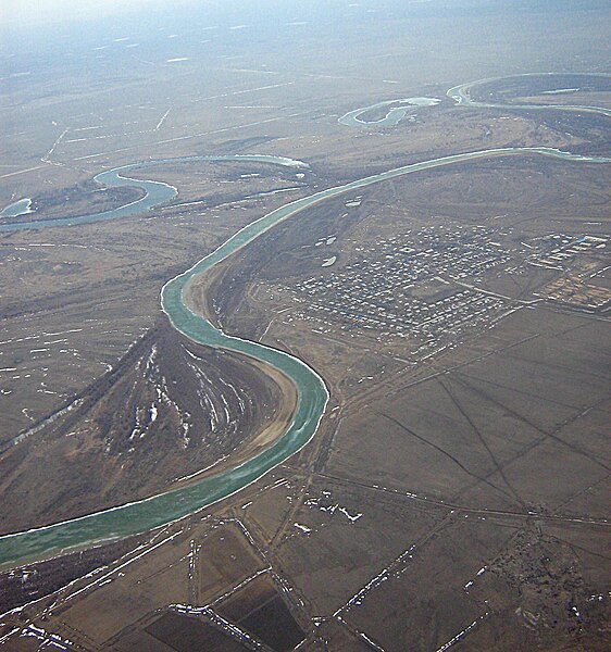
- 2008-04-03 10:06 Ds02006 1704×2272×??? (1594589 bytes) {{Information |Description= Ural river between [[Uralsk]] and [[Atyrau]], [[Kazakhstan]] |Source=self-made |Date= 10-MAR-2008 |Location= over Ural river, Kazakhstan |Author=~~~ |other_versions= }}
Kaagi sa payl
I-klik ang petsa/oras aron makit-an ang hulagway sa payl niadtong panahona.
| Petsa/Takna | Thumbnail | Mga dimensyon | Tiggamit | Komento | |
|---|---|---|---|---|---|
| kasamtangan | 07:04, 5 Hulyo 2010 | | 1,689 × 1,803 (651 KB) | Materialscientist | minor crop, constrastm unsharp mask (Gimp) |
| 12:24, 14 Septiyembre 2008 |  | 1,704 × 2,272 (1.52 MB) | File Upload Bot (Magnus Manske) | {{BotMoveToCommons|en.wikipedia}} {{Information |Description={{en|Ural river between en:Uralsk and en:Atyrau, en:Kazakhstan. North 47.446665, East 51.822681}} |Source=Transferred from [http://en.wikipedia.org en.wikipedia]; transferred to |
Mga paggamit sa payl
Ang mosunod nga mga panid misumpay niining payl:
Global nga paggamit sa payl
Kining ubang wiki naggamit ning maong payl:
- Paggamit sa af.wikipedia.org
- Paggamit sa ar.wikipedia.org
- Paggamit sa arz.wikipedia.org
- Paggamit sa ast.wikipedia.org
- Paggamit sa azb.wikipedia.org
- Paggamit sa ba.wikipedia.org
- Paggamit sa be-tarask.wikipedia.org
- Paggamit sa be.wikipedia.org
- Paggamit sa bg.wikipedia.org
- Paggamit sa bh.wikipedia.org
- Paggamit sa bn.wikipedia.org
- Paggamit sa bs.wikipedia.org
- Paggamit sa ca.wikipedia.org
- Paggamit sa cs.wikipedia.org
- Paggamit sa cu.wikipedia.org
- Paggamit sa cv.wikipedia.org
- Paggamit sa cy.wikipedia.org
- Paggamit sa de.wikipedia.org
- Paggamit sa el.wikipedia.org
- Paggamit sa en.wikipedia.org
- Paggamit sa es.wikipedia.org
- Paggamit sa eu.wikipedia.org
- Paggamit sa fi.wikipedia.org
- Paggamit sa frr.wikipedia.org
- Paggamit sa fr.wikipedia.org
- Paggamit sa gl.wikipedia.org
- Paggamit sa hi.wikipedia.org
- Paggamit sa hr.wikipedia.org
- Paggamit sa hsb.wikipedia.org
- Paggamit sa ht.wikipedia.org
- Paggamit sa hy.wikipedia.org
- Paggamit sa io.wikipedia.org
- Paggamit sa it.wikibooks.org
- Paggamit sa ja.wikipedia.org
- Paggamit sa kk.wikipedia.org
View more global usage of this file.