Payl:Villes assyriennes.PNG

Gidak-on ning maong paunang tan-aw: 800 x 578 ka mga piksel. Uban pang mga resoluyon: 320 x 231 ka mga piksel | 640 x 462 ka mga piksel | 1,024 x 740 ka mga piksel | 1,117 x 807 ka mga piksel.
Tibuok resolusyon (1,117 × 807 pixels, size sa payl: 1.3 MB, MIME type: image/png)

|
This historical map image could be re-created using vector graphics as an SVG file. This has several advantages; see Commons:Media for cleanup for more information. If an SVG form of this image is available, please upload it and afterwards replace this template with
{{vector version available|new image name}}.
It is recommended to name the SVG file “Villes assyriennes.svg”—then the template Vector version available (or Vva) does not need the new image name parameter. |
| Deskripsyon |
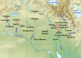
English: Map with the main cities of Assyria and Upper Mesopotamia during the medio-assyrian (ca. 1365-934 BC) and neo-assyrian period (ca. 934-609 BC). Français : Localisation des principales villes de l'Assyrie et de la Haute Mésopotamie durant les périodes médio-assyrienne (ca. 1365-934 av. J.-C.) et néo-assyrienne (ca. 934-609 av. J.-C.). |
| Petsa | (UTC) |
| Gigikanan | |
| Tagsulat |
|
| This is a retouched picture, which means that it has been digitally altered from its original version. Modifications: Ajout des noms des villes et des cours d'eau.. The original can be viewed here: Near East topographic map-blank.svg:
|
I, the copyright holder of this work, hereby publish it under the following licenses:
This file is licensed under the Creative Commons Attribution-Share Alike 3.0 Unported, 2.5 Generic, 2.0 Generic and 1.0 Generic license.
- Libre ka:
- sa pagsabwag – sa pagkopya, pag-apod-apod ug pagsabwag sa hinimo
- sa pag-remix – sa pag-adap sa binuhat
- Ubos sa mosunod nga mga kondisyon:
- atribusyon – Kinahanglan nimo nga hatagan ang angay nga kredito, maghatag usa ka link sa lisensya, ug ipakita kung adunay mga pagbag-o. Mahimo nimo kini buhaton sa bisan unsang makatarunganon nga paagi, apan dili sa bisan unsang paagi nga nagsugyot nga gi-endorso ka sa licensor o ang imong paggamit.
- share parehas – Kung imong gi-remix, gibag-o, o gibase sa materyal, kinahanglan nimo nga iapod-apod ang imong mga kontribusyon sa ilawom sa parehas o katugma nga lisensya sama sa orihinal.

|
Gitugot ang pagkopya, pag-apud-apod o/ug pag-usab ning maong dokumento ubos sa mga termino sa GNU Free Documentation License, Version 1.2 o mas bag-ong bersiyon nga gimantala sa Free Software Foundation; nga walay Invariant Sections, walay Front-Cover Texts, ug walay Back-Cover Texts. Ang kopya sa lisensiya gilakip sa bahin nga giulohang GNU Free Documentation License. |
You may select the license of your choice.
Original upload log
This image is a derivative work of the following images:
- File:Near_East_topographic_map-blank.svg licensed with Cc-by-sa-3.0,2.5,2.0,1.0, GFDL
- 2009-08-18T18:31:37Z Sémhur 2425x1581 (2442670 Bytes) 3 - New try
- 2009-08-17T15:39:22Z Sémhur 2425x1581 (1815374 Bytes) 2 - With the background...
- 2009-08-17T15:37:36Z Sémhur 2425x1581 (2836 Bytes) {{Information |Description={{en|1=Blank physical map of the [[:en:Near East|Near East]]}} {{fr|1=Carte physique vierge du [[:fr:Proche-Orient|Proche-Orient]].}} |Source={{own}} |Author=[[User:Sémhur|Sémhur]] |Date=2008-08-1
Uploaded with derivativeFX
Kaagi sa payl
I-klik ang petsa/oras aron makit-an ang hulagway sa payl niadtong panahona.
| Petsa/Takna | Thumbnail | Mga dimensyon | Tiggamit | Komento | |
|---|---|---|---|---|---|
| kasamtangan | 19:53, 22 Septiyembre 2010 | | 1,117 × 807 (1.3 MB) | Zunkir | {{Information |Description={{en|1=Map with the main cities of Assyria and Upper Mesopotamia during the medio-assyrian (ca. 1365-934 BC) and neo-assyrian period (ca. 934-609 BC).}} {{fr|1=Localisation des principales villes de l'Assyrie et de la Haute Més |
Mga paggamit sa payl
Ang mosunod nga mga panid misumpay niining payl:
Global nga paggamit sa payl
Kining ubang wiki naggamit ning maong payl:
- Paggamit sa ar.wikipedia.org
- Paggamit sa arz.wikipedia.org
- Paggamit sa ba.wikipedia.org
- Paggamit sa ca.wikipedia.org
- Paggamit sa en.wikipedia.org
- Paggamit sa es.wikipedia.org
- Paggamit sa eu.wikipedia.org
- Paggamit sa fr.wikipedia.org
- Assyrie
- Ninive
- Nimroud
- Flottage du bois
- Assur (dieu)
- Kar-Tukulti-Ninurta
- Arrapha
- Palais assyriens
- Astronomie mésopotamienne
- Dur-Sharrukin
- Utilisateur:Zunkir/Assyrie
- Balawat
- Utilisateur:Zunkir/cartothèque
- Empire néo-assyrien
- Utilisateur:Imanuel Plantier/Brouillon
- Tushhan
- Utilisateur:Zunkir/Empire néo-assyrien
- Paggamit sa fy.wikipedia.org
- Paggamit sa id.wikipedia.org
- Paggamit sa it.wikipedia.org
- Paggamit sa ja.wikipedia.org
- Paggamit sa ka.wikipedia.org
- Paggamit sa lt.wikipedia.org
- Paggamit sa no.wikipedia.org
- Paggamit sa pl.wikipedia.org
View more global usage of this file.