Payl:Vinson-Map.jpg

Gidak-on ning maong paunang tan-aw: 626 x 599 ka mga piksel. Uban pang mga resoluyon: 251 x 240 ka mga piksel | 501 x 480 ka mga piksel | 802 x 768 ka mga piksel | 1,070 x 1,024 ka mga piksel | 2,139 x 2,048 ka mga piksel | 3,207 x 3,070 ka mga piksel.
Tibuok resolusyon (3,207 × 3,070 pixels, size sa payl: 5.48 MB, MIME type: image/jpeg)
| Deskripsyon |
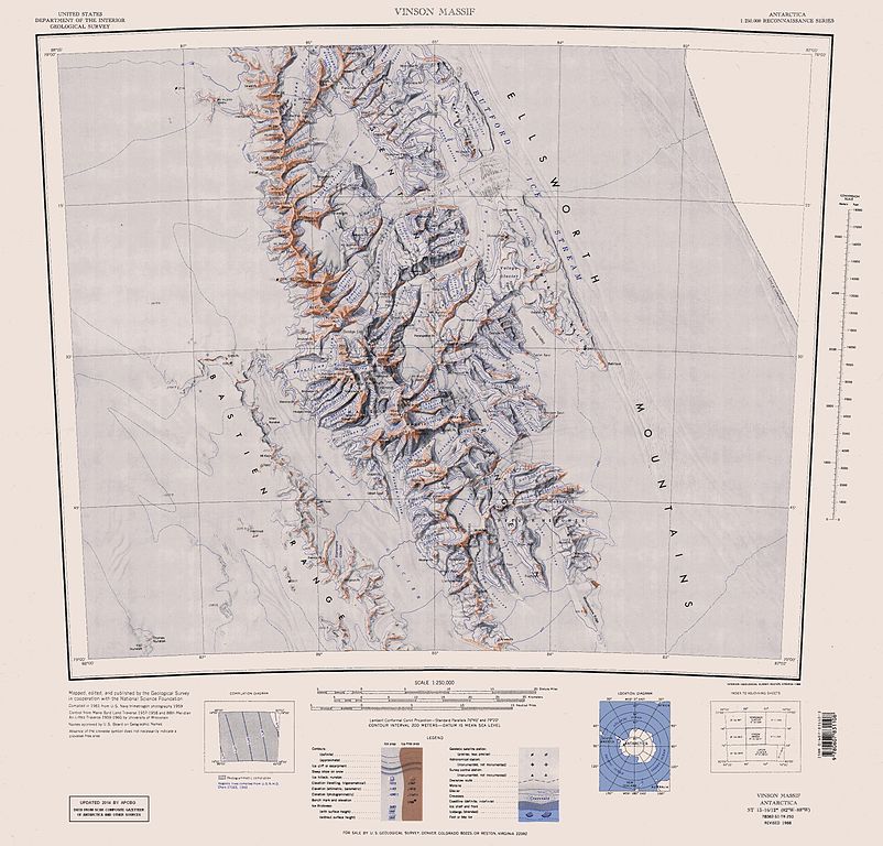
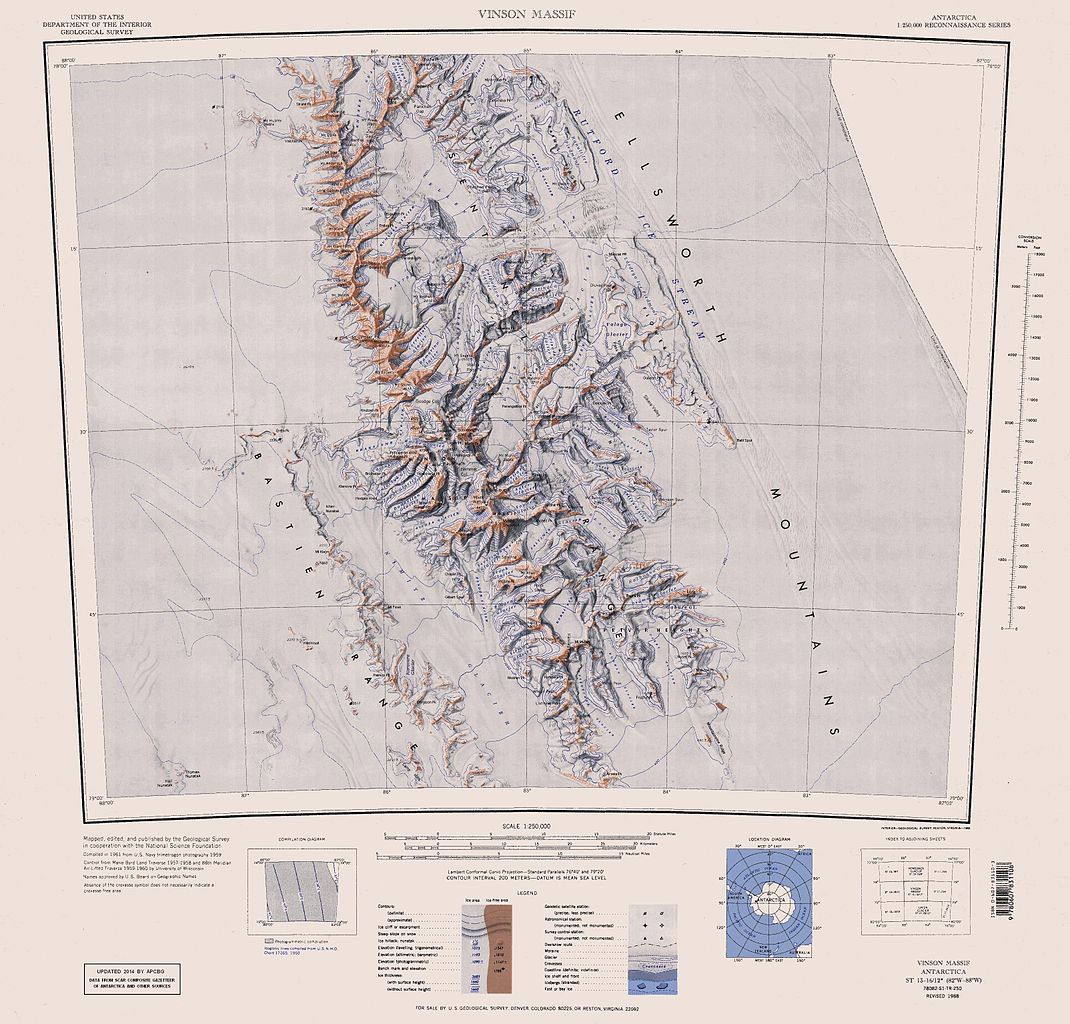
English: Map of Antarctica by the United States Antarctic Resource Center of the US Geological Survey (USGS). |
| Petsa | |
| Gigikanan | https://usarc.usgs.gov/drgs/dir1/c78082s1.jpg |
| Tagsulat | United States Department of the Interior: Geological Survey |
| Other versions |
Trimmed and updated version of Wikimedia Commons Image:C78082s1_Ant.Map_Vinson_Massif.jpg. |
This image is in the public domain in the United States because it only contains materials that originally came from the United States Geological Survey, an agency of the United States Department of the Interior. For more information, see the official USGS copyright policy.
|
Kaagi sa payl
I-klik ang petsa/oras aron makit-an ang hulagway sa payl niadtong panahona.
| Petsa/Takna | Thumbnail | Mga dimensyon | Tiggamit | Komento | |
|---|---|---|---|---|---|
| kasamtangan | 16:25, 22 Enero 2014 | | 3,207 × 3,070 (5.48 MB) | Apcbg | Updated with data from SCAR Composite Gazetteer of Antarctica and other sources. |
| 07:11, 27 Agosto 2013 |  | 3,207 × 3,070 (5.47 MB) | Apcbg | Updated with data from SCAR Composite Gazetteer of Antarctica and other sources. | |
| 16:34, 9 Hulyo 2011 |  | 3,207 × 3,070 (5.46 MB) | Apcbg | Updated with data from SCAR Composite Gazetteer of Antarctica and other sources. | |
| 17:34, 8 Marso 2011 |  | 3,207 × 3,070 (5.47 MB) | Apcbg | Updated with data from SCAR Composite Gazetteer of Antarctica and other sources. | |
| 16:52, 13 Oktubre 2010 |  | 3,207 × 3,070 (5.45 MB) | Apcbg | Updated with data from SCAR Composite Gazetteer of Antarctica and other sources. | |
| 10:27, 30 Enero 2007 |  | 3,207 × 3,070 (5.4 MB) | Apcbg | Map of Antarctica by the United States Antarctic Ressource Center of the US Geological Society. Trimmed version of Wikimedia image C78082s1_Ant.Map_Vinson_Massif.jpg {{PD-US}} Copyrights and Trademarks USGS-authored or produced data and information are |
Mga paggamit sa payl
Ang mosunod nga 22 panid misumpay niining payl:
- Allen, Mount (bukid, lat -78,72, long -84,93)
- Anderson (bukid)
- Bastien Range
- Bender Glacier
- Bentley (bukid)
- Brook Glacier
- Carey Glacier
- Craddock
- Kornicker Glacier
- Landolt
- Liptak
- Lishness Peak
- Long Peak (tumoy sa bukid sa Antartika)
- Milton (bukid)
- Nimitz Glacier
- Ostenso
- Owen Ridge
- Remington Glacier
- Rutford
- Strybing
- Thomas Glacier
- Wessbecher Glacier
Global nga paggamit sa payl
Kining ubang wiki naggamit ning maong payl:
- Paggamit sa ar.wikipedia.org
- Paggamit sa ast.wikipedia.org
- Paggamit sa az.wikipedia.org
- Mirovyane zirvəsi
- Zimornitsa zirvəsi
- Fuça zirvəsi
- Bezden zirvəsi
- Oreşak zirvəsi
- Qolemani zirvəsi
- Marsa buzlağı
- Patleyna buzlağı
- Embree buzlağı
- Kopsis buzlağı
- Padala buzlağı
- Ellen buzlağı
- Fonfon buzlağı
- Gerila buzlağı
- Rumyana buzlağı
- Delyo buzlağı
- Burdenis buzlağı
- Arapya buzlağı
- Pulpudeva buzlağı
- Mamarçev zirvəsi
- Rutford
- Paggamit sa bg.wikipedia.org
- Paggamit sa ca.wikipedia.org
- Paggamit sa de.wikipedia.org
View more global usage of this file.