Payl:Wadi Halhal, a tributary of Wadi Ghalilah.jpg

Gidak-on ning maong paunang tan-aw: 800 x 450 ka mga piksel. Uban pang mga resoluyon: 320 x 180 ka mga piksel | 640 x 360 ka mga piksel | 1,024 x 576 ka mga piksel | 1,280 x 720 ka mga piksel | 2,560 x 1,440 ka mga piksel | 4,000 x 2,250 ka mga piksel.
Tibuok resolusyon (4,000 × 2,250 pixels, size sa payl: 1.87 MB, MIME type: image/jpeg)
Mubong sugid:
| Deskripsyon |
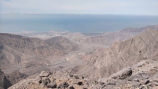
English: Wadi Halhal, a tributary of the Wadi Ghalilah. View from the Jabal ar Rahrah Ridge.
In the center of the photo, the village of Halhal and the confluence of Wadi Halhal with Wadi Ghalilah. In the background, the coast of the Persian Gulf and the port area and town of Ghalilah.
Español: Wadi Halhal, afluente del Wadi Ghalilah. Vista desde el Jabal ar Rahrah Ridge.
En el centro de la foto, el pueblo de Halhal y la confluencia del Wadi Halhal con el Wadi Ghalilah. Al fondo, la costa del Golfo Pérsico y la zona portuaria y localidad de Ghalilah. |
| Petsa | |
| Gigikanan | Kaugalingong trabaho |
| Tagsulat | LukasSimeone |
| Camera location | | View this and other nearby images on: OpenStreetMap |
|---|
Pagtugot
I, the copyright holder of this work, hereby publish it under the following license:
This file is licensed under the Creative Commons Attribution-Share Alike 4.0 International license.
- Libre ka:
- sa pagsabwag – sa pagkopya, pag-apod-apod ug pagsabwag sa hinimo
- sa pag-remix – sa pag-adap sa binuhat
- Ubos sa mosunod nga mga kondisyon:
- atribusyon – Kinahanglan nimo nga hatagan ang angay nga kredito, maghatag usa ka link sa lisensya, ug ipakita kung adunay mga pagbag-o. Mahimo nimo kini buhaton sa bisan unsang makatarunganon nga paagi, apan dili sa bisan unsang paagi nga nagsugyot nga gi-endorso ka sa licensor o ang imong paggamit.
- share parehas – Kung imong gi-remix, gibag-o, o gibase sa materyal, kinahanglan nimo nga iapod-apod ang imong mga kontribusyon sa ilawom sa parehas o katugma nga lisensya sama sa orihinal.
Kaagi sa payl
I-klik ang petsa/oras aron makit-an ang hulagway sa payl niadtong panahona.
| Petsa/Takna | Thumbnail | Mga dimensyon | Tiggamit | Komento | |
|---|---|---|---|---|---|
| kasamtangan | 23:31, 26 Marso 2023 | | 4,000 × 2,250 (1.87 MB) | LukasSimeone | Uploaded own work with UploadWizard |
Mga paggamit sa payl
Ang mosunod nga mga panid misumpay niining payl:
Global nga paggamit sa payl
Kining ubang wiki naggamit ning maong payl:
- Paggamit sa en.wikipedia.org
- Paggamit sa es.wikipedia.org
- Paggamit sa www.wikidata.org