Payl:Wallis vue du ciel.jpg

Gidak-on ning maong paunang tan-aw: 800 x 533 ka mga piksel. Uban pang mga resoluyon: 320 x 213 ka mga piksel | 640 x 427 ka mga piksel | 1,024 x 683 ka mga piksel | 1,280 x 853 ka mga piksel | 2,560 x 1,707 ka mga piksel | 5,184 x 3,456 ka mga piksel.
Tibuok resolusyon (5,184 × 3,456 pixels, size sa payl: 4.54 MB, MIME type: image/jpeg)
| Object location | | View this and other nearby images on: OpenStreetMap |
|---|
Mubong sugid:
| Deskripsyon |
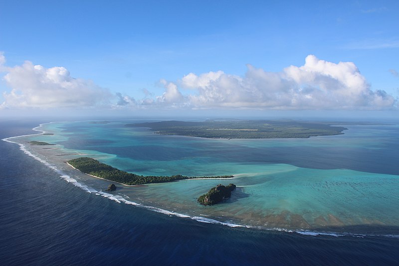
Français : Observer Wallis du ciel change radicalement la perspective de l'île. On y voit le lagon dans toute sa splendeur, la barrière de corail est nettement définie, et les différents îlots (dans l'ordre, de droite à gauche : Nukufotu, Nukula'ela'e (tout petit), Nukuloa puis Nukuteatea et enfin Nukutapu). Avec un peu de chance, on peut même voir quelques raies qui sautent, de requins qui nagent, ou quelques fois, des baleines perdues dans le lagon !
English: Aerial photograph of Wallis island (South Pacific). The North of the lagoon and the coral reef is visible with the islets Nukufotu, Nukula'ela'e (very small), Nukuloa then Nukuteatea and finally Nukutapu. The mainland (Wallis island) is visible in the background. |
| Petsa | |
| Gigikanan | Kaugalingong trabaho |
| Tagsulat | Anna Vinet |
| Other versions |
.jpg)

.jpg)
Pagtugot
I, the copyright holder of this work, hereby publish it under the following license:
This file is licensed under the Creative Commons Attribution-Share Alike 4.0 International license.
- Libre ka:
- sa pagsabwag – sa pagkopya, pag-apod-apod ug pagsabwag sa hinimo
- sa pag-remix – sa pag-adap sa binuhat
- Ubos sa mosunod nga mga kondisyon:
- atribusyon – Kinahanglan nimo nga hatagan ang angay nga kredito, maghatag usa ka link sa lisensya, ug ipakita kung adunay mga pagbag-o. Mahimo nimo kini buhaton sa bisan unsang makatarunganon nga paagi, apan dili sa bisan unsang paagi nga nagsugyot nga gi-endorso ka sa licensor o ang imong paggamit.
- share parehas – Kung imong gi-remix, gibag-o, o gibase sa materyal, kinahanglan nimo nga iapod-apod ang imong mga kontribusyon sa ilawom sa parehas o katugma nga lisensya sama sa orihinal.
This picture has been imported as part of the Photographiez les Outre-Mer contest, organized by Wikimédia France, the French Development Agency and the Ministry of Overseas France.
|

|
This image has been assessed under the valued image criteria and is considered the most valued image on Commons within the scope: Aerial photographs of Wallis lagoon seen from the North. You can see its nomination here. |
Kaagi sa payl
I-klik ang petsa/oras aron makit-an ang hulagway sa payl niadtong panahona.
| Petsa/Takna | Thumbnail | Mga dimensyon | Tiggamit | Komento | |
|---|---|---|---|---|---|
| kasamtangan | 10:37, 11 Agosto 2018 | | 5,184 × 3,456 (4.54 MB) | Vinean10 | User created page with UploadWizard |
Mga paggamit sa payl
Ang mosunod nga mga panid misumpay niining payl:
Global nga paggamit sa payl
Kining ubang wiki naggamit ning maong payl:
- Paggamit sa en.wikipedia.org
- Paggamit sa fr.wikipedia.org
- Paggamit sa hi.wikipedia.org
- Paggamit sa id.wikipedia.org
- Paggamit sa incubator.wikimedia.org
- Paggamit sa is.wikipedia.org
- Paggamit sa it.wikipedia.org
- Paggamit sa rn.wikipedia.org
- Paggamit sa to.wikipedia.org
- Paggamit sa www.wikidata.org