Payl:Waterside.jpg

Gidak-on ning maong paunang tan-aw: 800 x 600 ka mga piksel. Uban pang mga resoluyon: 320 x 240 ka mga piksel | 640 x 480 ka mga piksel | 1,024 x 768 ka mga piksel | 1,280 x 960 ka mga piksel | 2,560 x 1,920 ka mga piksel | 2,816 x 2,112 ka mga piksel.
Tibuok resolusyon (2,816 × 2,112 pixels, size sa payl: 2.52 MB, MIME type: image/jpeg)
|
This is an image of a place or building that is listed on the National Register of Historic Places in the United States of America. Its reference number is 401. |
| Camera location | | View this and other nearby images on: OpenStreetMap |
|---|
| Deskripsyon |
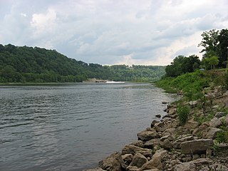
English: View of the Allegheny River Lock and Dam No. 7, a National Register of Historic Places property on the Allegheny River at Kittanning, Pennsylvania, United States. |
||
| Petsa | Taken on 7 Hunyo 2008 | ||
| Gigikanan | Kaugalingong trabaho | ||
| Tagsulat | User:Nyttend | ||
| Pagtugot (Paggamit pag-usab niini nga file) |
|
Kaagi sa payl
I-klik ang petsa/oras aron makit-an ang hulagway sa payl niadtong panahona.
| Petsa/Takna | Thumbnail | Mga dimensyon | Tiggamit | Komento | |
|---|---|---|---|---|---|
| kasamtangan | 04:03, 17 Disyembre 2008 | | 2,816 × 2,112 (2.52 MB) | Nyttend | {{Location|40|49|16|N|79|31|44|W}} {{Information |Description=View of the {{w|Allegheny River Lock and Dam No. 7}}, a {{w|National Register of Historic Places}} property on the {{w|Allegheny River}} at {{w|Kittanning, Pennsylvania|Kittanning}}, {{w|Pennsy |
Mga paggamit sa payl
Ang mosunod nga mga panid misumpay niining payl:
Global nga paggamit sa payl
Kining ubang wiki naggamit ning maong payl:
- Paggamit sa en.wikipedia.org
- Paggamit sa tl.wikipedia.org
- Paggamit sa www.wikidata.org