Santo Tomas ug Prinsipe
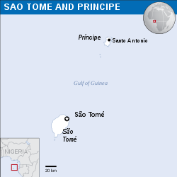
Ang Santo Tomas ug Prinsipe, Sao Tome ug Principe o São Tomé et Príncipe (/ˌsaʊ təˈmeɪ...ˈprɪnsᵻpə, -peɪ/). usa ka islang nasod sa Golpo sa Guinea, duol sa kasadpang baybayon sa ekwatoryal nga Aprika. Ang nasod gitibuok sa duha ka isla: ang São Tomé ug Príncipe. Ang Gabon mao ang labing duol nga nasod sa kontinente sa Aprika.
- ↑ "Nationality". The World Factbook. Retrieved July 17, 2012.
- ↑ Octávio Amorim Neto; Marina Costa Lobo (2010). "Between Constitutional Diffusion and Local Politics: Semi-Presidentialism in Portuguese-Speaking Countries". Social Science Research Network. SSRN 1644026. Retrieved June 6, 2014.
{{cite web}}: CS1 maint: multiple names: authors list (link) - ↑ "Ministério Dos Negócios Estrangeiros e Comunidades da República Democrática de São Tomé e Príncipe".
- ↑ "World Population Prospects 2022". population.un.org. United Nations Department of Economic and Social Affairs, Population Division. Retrieved July 17, 2022.
- ↑ "World Population Prospects 2022: Demographic indicators by region, subregion and country, annually for 1950-2100" (XSLX). population.un.org ("Total Population, as of 1 July (thousands)"). United Nations Department of Economic and Social Affairs, Population Division. Retrieved July 17, 2022.
- ↑ 6.0 6.1 6.2 6.3 "São Tomé and Príncipe". International Monetary Fund. Retrieved 2013-04-17.
- ↑ "GINI index". World Bank. Retrieved 26 July 2013.
- ↑ "2016 Human Development Report" (PDF). United Nations Development Programme. 2016. Retrieved 21 March 2017.
Democratic Republic of São Tomé and Príncipe República Democrática de São Tomé e Príncipe (Portuguese) | |
|---|---|
| Motto: "Unidade, Disciplina, Trabalho" (Portuguese) "Unity, Discipline, Labour" | |
| Awit: Independência total Total Independence | |
 Location of Santo Tomas ug Prinsipe (dark blue) – in Africa (light blue & dark grey) | |
 | |
| Kapital and largest city | São Tomé 0°20′N 6°44′E / 0.333°N 6.733°E |
| Opisyal mga pinulongan | Portuguese |
| Giila rehiyon mga pinulongan | |
| Demonym(s) |
|
| Gobyerno | Unitary semi-presidential republic[2] |
| Carlos Vila Nova | |
| Lehislatura | National Assembly |
| Independence | |
• from Portugal | 12 July 1975 |
| Area | |
• Total | 1,001[3] km2 (386 sq mi) (171th) |
• Tubig (%) | Negligible |
| Populasyon | |
• 2021 estimate | 223,107[4][5] (178th) |
• 2012 census | 178,739 |
• Densidad | 199.7/km2 (517.2/sq mi) (69th) |
| GDP (PPP) | 2017 estimate |
• Total | $685 million[6] |
• Per capita | $3,220[6] |
| GDP (nominal) | 2017 estimate |
• Total | $355 million[6] |
• Per capita | $1,668[6] |
| Gini (2010) | 33.9[7] medium |
| HDI (2017) | medium · 143rd |
| Salapi | Dobra (STN) |
| Time zone | UTC+0 (GMT) |
| Dapit sa pagmaneho | right |
| Code sa pagtawag | +239 |
| ISO 3166 code | ST |
| Internet TLD | .st |

